Penistone to Shepley linear
South Yorkshire Walk
County/Area - South Yorkshire & West Yorkshire - Barnsley
Author - Andy Chaplin
Length - 8.0 miles / 13 km Ascent - 700 feet / 212 metres
Time - 4 hours 40 minutes Grade - easy/mod
Maps 

| Ordnance Survey Explorer OL1 | Sheet Map | 1:25k | BUY |
| Anquet OS Explorer OL1 | Digital Map | 1:25k | BUY |
Walk Route Description
Click image to visit gallery of 3 images.
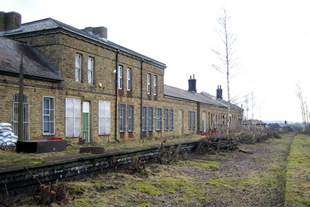
This linear Barnsley walk starts and finishes at Penistone station (grid ref. SE251032). Being a one-way walk, the return journey relies on the hourly train service from Shepley back to Penistone. There is some parking at Penistone station and even more at the car park next to the Paramount cinema/theatre which is nearby. The cinema itself is well worth a visit at some other time as it is one of very few cinemas that still has an interval for ice-creams and drinks from the bar.
This 8 mile route is actually two consecutive walks that were devised, described and marked by the Denby Dale Walkers are Welcome organisation. There were two leaflets on line from 2013 that describe the route and the sights in some detail.
However, by way of a short introduction, the walk is a train enthusiast's delight as it takes in part of the old Woodhead line from Penistone. The walk also passes the impressive viaducts at Penistone and Denby Dale on the current Sheffield to Huddersfield line and gets tantalisingly close to Kirklees Light Railway at Shelley.
The walk also offers some great views of the South Yorkshire and West Yorkshire countryside - notably from Royd Moor back towards the Don valley at Penistone and from Upper Denby down to the Dearne valley at Denby Dale.
The route is well marked either as the Pen-Den Trail or the Denby Dale to Shepley Trail. All in all it is a great couple of walks - so many thanks to Denby Dale Walkers Are Welcome for the routes and information.
Other walks nearby
| Walk 2726 | Penistone Circular from Scout Dike Reservoir | moderate | 8.3 miles |
| Walk 2238 | Thurgoland Boundary Walk Oxspring | easy/mod | 8.6 miles |
| Walk 2825 | Silkstone Circular & Cannon Hall Country Park | moderate | 10.4 miles |
| Walk 3401 | From Langsett to Crowden via Woodhead | moderate | 11.0 miles |
| Walk 1581 | Langsett Reservoir | easy | 3.0 miles |
| Walk 2086 | Stainborough Castle, Wentworth Castle & Worsbrough | easy/mod | 8.9 miles |
| Walk 1401 | Hordron Road and the Little Don | easy/mod | 5.0 miles |
| Walk 2231 | The Eastern Edges | hard | 25.0 miles |
| Walk 1526 | Cats Clough Head & Outer Edge | moderate | 9.0 miles |
| Walk 1695 | Flouch & Winscar circular | easy/mod | 9.0 miles |
Recommended Books & eBooks
No suggestions for this area.Messaging & Social Media
Message Walking Britain and follow the latest news.

Mountain Weather
Stay safe on the mountains with detailed weather forecasts - for iOS devices or for Android devices.