Walk 2330 - printer friendly version
Quantock Hills from Dead Woman's Ditch Walk
Author - Lou Johnson
Length - 9.2 miles / 15 km
Ascent - 2000 feet / 606 metres
Grade - moderate
Start - OS grid reference ST161382
Lat 51.1369010 + Long -3.2005695
Postcode TA4 4AB (approx. location only)
This walk in the Quantock Hills visits many highlights of this beautiful area with its combes (valleys) nestling below rounded hills. The route offers wide ranging views once height is gained and provides excellent waling on well-used paths. Detailed instructions are difficult to explain so a good sense of direction supported by the relevant OS 1:25000 map is required. Remember this can be a confusing landscape especially in poor visibility.
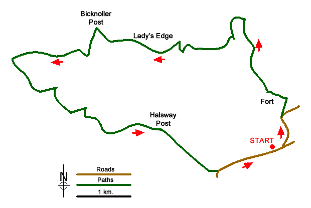
The walk starts from the car park at Dead Woman's Ditch (grid ref. ST161382) located just under 2 miles east of Crowcombe on the road to Nether Stowey. After parking exit the car park, turn right and then walk left following the lane signed to Doddington. After 700 metres, the lane descends and bears right. Take the bridleway on the left (grid ref. ST161387). This leads north towards Dowsborough Hill Fort. Ignore two paths on the left before turning left to the hill fort. Follow the boundary wall on the north side of the fort and descend on the ridge-top bridleway above Holford Combe (which is to your left). Cross Woodlands Hill and continue north to reach a junction of bridleways after 700 metres (grid ref. ST155405).
Turn west and descend into Holford Combe soon reaching a stream (grid ref. ST152402). Cross the stream and head half left up onto Lower Hare Knapp. Cross the ridge and continue west, descending into Somerton Combe. Nearing the valley floor (grid ref. ST143399), bear sharp right at a junction of bridleways and descend to the river. Cross the river (grid ref. ST143399) and turn north. Take the path on your left heading west up the valley below Lady's Edge. This leads to the Bicknoller Post after a mile. From here you are rewarded with some fine views to the coast at Minehead.
From the Bicknoller Post, head south for a short way, before taking a path on your right along a grassy path to drop down into Bicknoller Combe following the Macmillan Way. Nearing the village of Bicknoller you reach a junction with the Coleridge Way which comes in from the right. Continue straight ahead and after 100 metres turn left along a path signed to Quantock Moor. Continue beneath Trendle Ring earthworks to reach a tarmac lane (grid ref. ST118392). Turn left here and then bear right on a grassy path signed to Crowcombe.
Reaching Paradise Combe (grid ref. ST124387). Turn left into the Combe and take the second path on your right (grid ref. ST126389). Continue on this bridleway to reach Halsway Post after just over a mile. From the post, head south-east over Hurley Beacon to Crowcombe Park Gate (grid ref. ST148377). At the gate walk half left to reach the road from Crowcombe to Nether Stowey. Cross the road and bear right following the path with the road to your left. This path leads back to the start.
Messaging & Social Media
Message Walking Britain and follow the latest news.

Mountain Weather
Stay safe on the mountains with detailed weather forecasts - for iOS devices or for Android devices.