Walk 2339 - printer friendly version
Milk Hill the highest point in Wiltshire Walk
Author - Lou Johnson
Length - 3.0 miles / 4.9 km
Ascent - 400 feet / 121 metres
Grade - easy
Start - OS grid reference SU116638
Lat 51.373141 + Long -1.8347383
Postcode SN8 4JX (approx. location only)
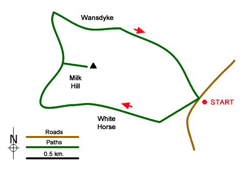
This short walk takes you to the highest point in Wiltshire, which despite its status probably offers less of a view than many points nearby! The route is easy to follow and apart from Milk Hill's summit offers some wonderful views across the downland and passes some points of interest along the way. The start is a small car park on the minor road between Lockeridge and Alton Barnes at grid ref. SU116638.
After parking, cross the road and take the path heading southwest through a field climbing gently across the northern flank of Walkers Hill. At a junction of paths (grid ref. SU112635). Here bear right and follow the path towards Milk Hill that passes above the White Horse carved in the grassland. The path turns north with a flat filed on your right that forms the summit area of Milk Hill. The highest point is not that marked on OS maps but a point surrounded by the 295 metre contour on maps. This can be accessed via a gate and you can then decide for yourself which is the highest point!
To continue follow the path north to Wansdyke which is a medieval defensive ditch. Here turn right along the White Horse Trail. After just over 400 metres bear right on to a path that descends gradually back to the road and the start of the walk.
Messaging & Social Media
Message Walking Britain and follow the latest news.

Mountain Weather
Stay safe on the mountains with detailed weather forecasts - for iOS devices or for Android devices.