Ripon Rowel Walk Leg 4 - Ilton to Grewelthorpe
Nidderdale AONB Walk
Region - Nidderdale AONB
County/Area - North Yorkshire - Nidderdale AONB
Author - Phil Catterall
Length - 10.5 miles / 17.1 km Ascent - 1400 feet / 424 metres
Time - 6 hours 40 minutes Grade - moderate
Maps 

| Ordnance Survey Explorer 298 | Sheet Map | 1:25k | BUY |
| Anquet OS Explorer 298 | Digital Map | 1:25k | BUY |
| Ordnance Survey Explorer 302 | Sheet Map | 1:25k | BUY |
| Anquet OS Explorer 302 | Digital Map | 1:25k | BUY |
| Ordnance Survey Landranger 99 | Sheet Map | 1:50k | BUY |
| Anquet OS Landranger 99 | Digital Map | 1:50k | BUY |
Walk Route Description
Click image to visit gallery of 6 images.
Leg 4 takes us to the Druids' Temple, and the town of Masham, passing by the famous "Theakston's of Masham" Brewery. Towards the end we track the route of the River Ure and navigate through Hackfall Woods, currently being regenerated (2008) by contractors working for The Woodland Trust, thanks to a lottery grant. Public transport is not available. I suggest two cars be used or a car and taxi (approx £ 16 at 2008 prices) to return from Grewelthorpe back to Ilton. A suggested parking spot at the start in Ilton is either grid ref. SE191781 (room for 3 cars) or at the grass triangle grid ref. SE189783 (more space here). Parking in Grewelthorpe village around grid ref. SE230762 is plentiful.
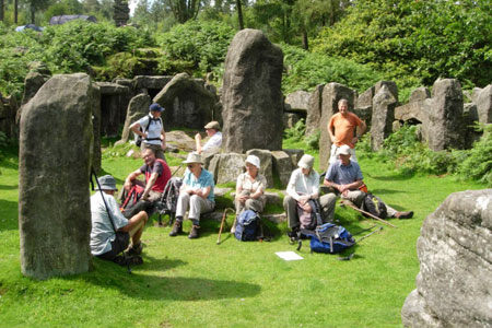
From Ilton head north west and downhill on the tarmac lane passing an original red telephone box on the right. Immediately after passing a coniferous wood (Sole Beck Plantation) take the track on the left heading uphill. After 300m a path turns right to climb up to High Knowle (Farm) prominent above you. Follow the footpath around the house to head up to Knowle Lane. Turn left at the lane to make a detour from the Ripon Rowel to the Druids' Temple. At the road end a path turns right into the woodland. Keep to the left hand path to arrive at the Temple (pictured). This marvellous folly took fifty years to build in the early 19th century.
After exploring the temple return to the tarmac road north and the path junction west of High Knowle. Turn left now back on the Rowel and head for some huge stone gateposts 300m in the distance. I believe that these were built using stone left over from the Temple. Following the line of the wood to your left you look down on Low Knowle Farm (pictured). Head downhill passing through small fields, looking for signs of a field path at grid ref. SE168793. At this point turn sharply right across the field on a bearing of 40 degrees. It is very easy to go further and end up walking through scrubland, so make sure you turn sharply right before you see any bracken.
The route follows Hall Wood passing Broadmires (Farm) before reaching a tarmac lane at grid ref. SE183797. Continue straight on to the bridge crossing the River Burn, a river which we will follow after Masham. Continue on the public road to take the next right, Low Moor Lane, a gravel track that is almost a mile long. There are lovely views on a good day here up to Swinton Park (pictured). When a T junction is reached, fork left for 300m and then at the track junction take a footpath on your right. Now head due east to Masham and soon the church steeple will be seen. The footpath ends alongside a large factory on your left, so Masham does have some industry as well as its brewery it seems. Continue through a residential area turning right at the first main road junction, to pass the Theakston Brewery (pictured). After the brewery turn immediately left into an alley which takes you into the town square. There are public toilets in a car park behind a pub in the far left corner of the Market Place as you walk into it. Masham has plenty of amenities, good teashops, pubs etc and Market days are Wednesdays and Saturdays.
Leave the Market Place by the north eastern corner (the road left of the church looking from the square). This cul de sac leads into a footpath. If you look carefully as you leave the Market Place you will see the familiar Ripon Rowel logo on the wall corner on your right. The well walked path now leads to the River Ure, and you follow its course until the River Burn tributary forces you to detour west to Low Burn Bridge (pictured). You meet Thorpe Road, cross the bridge and take the footpath down the opposite side of the River Burn. The path is narrow here, and subsiding in places, so watch your footing. The path improves when the Burn meets the Ure and you are walking on meadowland. Follow the river for one mile and you enter Nutwith Cote Wood which runs into Hackfall Wood. William Aislabie created this woodland around 1750 and built several follies deep within it. The wood is now managed by the Woodland Trust who are overseeing a programme to regenerate it.
You are nearing the end of this leg of the Ripon Rowel as you leave the route and the line of the Ure at grid ref. SE235775 heading gradually uphill to Grewelthorpe village on a SSW heading. At path junction (grid ref. SE234772) you can detour to the pond 150m NNW and see one of Aislabie's follies - currently being renovated (2008). Return back to the junction (look for the high waterfall on your right amongst trees - pictured) and continue uphill through the wood to a smaller man made waterfall and footbridge before joining the public road at grid ref. SE230767. Go uphill to the road junction turning left into the village. There is a public house here - The Crown Inn (Tel: 01765 658210) but I advise checking opening hours before your walk if you wish to enjoy refreshment here.
The fifth leg of this walk can be found here Walk 2407. This section takes you from Mowbray Point back into Hackfall Woods and thence on to Ripon Cathedral to complete the walk.
Other walks nearby
| Walk 2407 | Ripon Rowel Walk Leg 5 - Grewelthorpe to Ripon | moderate | 12.0 miles |
| Walk 1929 | River Ure & Nutwith Common from Masham | easy/mod | 6.6 miles |
| Walk 2572 | West Scrafton & Middlesmoor from Lofthouse | mod/hard | 18.0 miles |
| Walk 3659 | Scar House Reservoir, Dale Edge & Middlesmoor | moderate | 9.0 miles |
| Walk 2405 | Ripon Rowel Walk Leg 3 - Sawley to Ilton | moderate | 11.0 miles |
| Walk 3528 | Fountains Abbey & Markenfield Hall | moderate | 8.7 miles |
| Walk 1571 | Scar House & Angram Reservoirs | easy | 4.0 miles |
| Walk 2261 | Pateley Bridge & Nidderdale Way | easy/mod | 7.1 miles |
| Walk 3726 | Brimham Rocks Circular | easy | 4.7 miles |
| Walk 2403 | Ripon Rowel Walk Leg 1 - Ripon to South Stainley | easy/mod | 10.0 miles |
Recommended Books & eBooks
Trail and Fell Running in the Yorkshire Dales
 Guidebook to 40 of the best trail and fell runs in the Yorkshire Dales National Park. Ranging from 5 to 24 miles, the graded runs start from bases such as Ribblehead, Dent, Sedbergh, Malham and Grassington and take in the region's diverse delights, from castles and waterfalls to iconic mountains such as Whernside, Ingleborough and Pen Y Ghent.
More information
Messaging & Social Media
Message Walking Britain and follow the latest news.

Mountain Weather
Stay safe on the mountains with detailed weather forecasts - for iOS devices or for Android devices.