Ripon Rowel Walk Leg 5 - Grewelthorpe to Ripon
North Yorkshire Walk
County/Area - North Yorkshire - Vale of York
Author - Phil Catterall
Length - 12.0 miles / 19.5 km Ascent - 600 feet / 182 metres
Time - 6 hours 40 minutes Grade - moderate
Maps 

| Ordnance Survey Explorer 298 | Sheet Map | 1:25k | BUY |
| Anquet OS Explorer 298 | Digital Map | 1:25k | BUY |
| Ordnance Survey Landranger 99 | Sheet Map | 1:50k | BUY |
| Anquet OS Landranger 99 | Digital Map | 1:50k | BUY |
Walk Route Description
Click image to visit gallery of 6 images.
Continuing on the final leg of the 50 mile Ripon Rowel long distance walk. The walk tracks the course of the River Ure passing through woodland early on, and then the area known as Ripon Parks, before entering the city of Ripon. No public transport is available - the use of two cars is suggested or a taxi (P&P Cars Ripon Tel: 0800 0328192 provided good service) to Grewelthorpe ( £ 15 at 2008 prices). Free all day street parking is available in Church Lane Ripon at grid ref SE308713. The path was partly obstructed in August 2008 near North Stainley. This was reported to North Yorkshire CC and The Ramblers Association (see text).
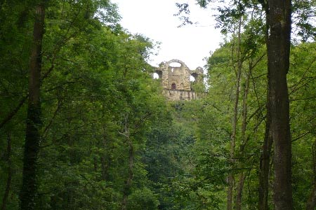
The walk starts from the newly created free car park for Hackfall Wood (grid ref. SE230775). Take the public footpath from here heading NE until you reach the edge of the wood. Turn right at the path junction to join the Ripon Rowel. Several paths exist in Hackfall so try to keep as close to the River Ure as you can. You soon drop downhill to Fisher's Hall a folly built in the 18th Century for the Head Gardener of Hackfall Wood, Mr Fisher. Look back up the path behind you to the top of the wood. This is Mowbray point and you will see The Ruin. The Woodland Trust is improving the wood as a long term project, so expect to encounter a few boggy sections on the woodland path. The Rowel path is more distinct once you enter Mickley Barras Wood, however you soon encounter the dreaded Himalayan Balsam and in summer you just have to push your way through it. This fast spreading and invasive plant is encountered over most of the route.
Leave the woodland in due course and join a lane at High Bank, before passing through the village of Mickley - no pub or shop available. Turn left off the road onto a track at grid ref. SE258770 to continue following the course of the Ure. At grid ref. SE262771 there is a seat made up of logs - this makes an ideal lunch/rest stop. Head north and at Quarry Hill look out for the path crossing a poor stile (grid ref. SE 269781), midway along the fence line. Cross the field diagonally (subject to crops - none in August 2008), to emerge on to the farm track leading to Quarry House. Now make for Tanfield Bridge on the A6108. Pubs and a shop are available in West Tanfield, a short detour from the Rowel. The Ure is becoming a mighty river now as you realise when you reach the weir. At Sleningford Water Mill there is a well managed 14 acre caravan and camping park and the Rowel goes straight through the grounds. A shop, toilets and other amenities are available here. After the park some erosion of the river bank has taken place and the path has had a minor reroute.
At grid ref. S 282781 make sure you take the right fork or you end up on the riverbank. Go through the gate here after the fork and then turn immediately left to head South East - do not follow the sign straight on to North Stainley. Continue SE now towards Sleningford Grange - the path has been rerouted slightly at grid ref. SE285776 and then follows the outside of the wood. At grid ref. SE286774 the path has been blocked by a low fence and whoever has done this is attempting to make you continue across the field. The path is accessible if you step over the fence to exercise your right of way. Continue and emerge at the A6108 road at grid ref. SE285773 where you turn left and head for North Stainley. It was noted that the Rowel signage at the drive end here had been turned so that it was not visible from the road. This and the obstruction to the path were reported to the County Council so the problem should now have been resolved.
After passing the village cricket pitch turn left along the track to Manor Farm - this is now a well laid out estate of distinctive homes. The track takes you through pleasant country until you reach an unsightly wide gravel access road to a large quarry at grid ref. SE296764. Continue on this wide road for 300m and then head east for High Batts - a private nature reserve, well known to birdwatchers and naturalists in this area. Passing a car park enter the area of North Parks. CAUTION HERE - this area is used by the Army for exercises and signs warn you not to pick up any objects. We saw numerous bullet cases on the track. Once past North Parks the track becomes a tarmac road passing Black Heath and Queen Mary's Ponds. At SE 308737 take the track left to South Parks, a pig farm. The path goes through farm buildings before turning south to head for Ripon through mainly livestock fields. There are caravan parks on both sides of the Ure now. Keep left on the path along the edge of the woodland until you reach the A6108 at North Bridge. Cross the road into Magdalen's Road. After 150m take the Rowel footpath left which takes you under the main A61 Ripon bypass. The path is well walked now by people from the town and there is little to see except the Cathedral to your right, which is your intended destination. At SE 325709 you reach the River Skell and need to turn west to head for the city centre and the Cathedral. Again you pass under the A61 and then slightly away from the Skell into a residential street before returning to its banks at the footbridge which you do not cross. Turn right and follow the path into Agnesgate, turning left after 200m into High Street Agnesgate to arrive at the rear entrance to the graveyard at SE 316710. Go through the gate and around the Cathedral side to the front. Your 50 mile Ripon Rowel Walk is now complete. The tourist information centre is across the road should you need it.
Other walks nearby
| Walk 1929 | River Ure & Nutwith Common from Masham | easy/mod | 6.6 miles |
| Walk 2406 | Ripon Rowel Walk Leg 4 - Ilton to Grewelthorpe | moderate | 10.5 miles |
| Walk 3528 | Fountains Abbey & Markenfield Hall | moderate | 8.7 miles |
| Walk 2405 | Ripon Rowel Walk Leg 3 - Sawley to Ilton | moderate | 11.0 miles |
| Walk 2403 | Ripon Rowel Walk Leg 1 - Ripon to South Stainley | easy/mod | 10.0 miles |
| Walk 3726 | Brimham Rocks Circular | easy | 4.7 miles |
| Walk 2572 | West Scrafton & Middlesmoor from Lofthouse | mod/hard | 18.0 miles |
| Walk 2261 | Pateley Bridge & Nidderdale Way | easy/mod | 7.1 miles |
| Walk 3659 | Scar House Reservoir, Dale Edge & Middlesmoor | moderate | 9.0 miles |
| Walk 3507 | Dacre Banks Circular | easy/mod | 6.5 miles |
Recommended Books & eBooks
Trail and Fell Running in the Yorkshire Dales
 Guidebook to 40 of the best trail and fell runs in the Yorkshire Dales National Park. Ranging from 5 to 24 miles, the graded runs start from bases such as Ribblehead, Dent, Sedbergh, Malham and Grassington and take in the region's diverse delights, from castles and waterfalls to iconic mountains such as Whernside, Ingleborough and Pen Y Ghent.
More information
Messaging & Social Media
Message Walking Britain and follow the latest news.

Mountain Weather
Stay safe on the mountains with detailed weather forecasts - for iOS devices or for Android devices.