Ebrington & Hidcote from Ilmington Walk
Walk 2408 - Route Maps
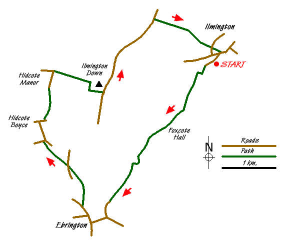
Route Map
Digital Maps - Copyright © 2011-2024. All rights reserved.
Sketch Map
Suggested Maps 

| Ordnance Survey Explorer 205 | Sheet Map | 1:25k | BUY |
| Anquet OS Explorer 205 | Digital Map | 1:25k | BUY |
| Ordnance Survey Landranger 151 | Sheet Map | 1:50k | BUY |
| Anquet OS Landranger 151 | Digital Map | 1:50k | BUY |
It is recommended you take a map. The preferred scale is 1:25k.
Start Point Details
Ordnance Survey Grid Ref SP210433
Latitude 52.087656 Longitude -1.694926
Postcode CV36 4LD
what3words start snores.weeded.alleyway
Walk description may contain detailed information on the start point for this walk.
Further Information
Cotswolds
The Cotswold National Landscape (formerly AONB) covers about 800 square miles in six counties of England. It is mostly farmland, both cultivated and pasture, with some areas of woodland and open upland. Bearing this in mind staying on signed rights of way is important so as to maintain the important balance between landowner and visitor. Cotswolds Walking Guide
Warwickshire
The county of Warwickshire is in the English Midlands. The north and centre of the county are the areas with the highest population density. The north offers undulating countryside in contrast to the largely rural and sparsely populated south, which contains a small section of the Cotswolds. The highest point in the county, at 261 m (856 ft), is Ebrington Hill, on the border with Gloucestershire. The featured walks include sections of the Millennium Way and Heart of England Way.
Walk grading - Learn how each walk is assessed and select a walk to suit your ability and experience by going to Walk Grading Details.
Messaging & Social Media
Message Walking Britain and follow the latest news.

Mountain Weather
Stay safe on the mountains with detailed weather forecasts - for iOS devices or for Android devices.