Bredon Hill Circular from Elmley Castle
Cotswolds Walk
Region - Cotswolds
County/Area - Worcestershire
Author - Lou Johnson
Length - 10.6 miles / 17.2 km Ascent - 1800 feet / 545 metres
Time - 7 hours 10 minutes Grade - moderate
Maps 

| Ordnance Survey Explorer 190 | Sheet Map | 1:25k | BUY |
| Anquet OS Explorer 190 | Digital Map | 1:25k | BUY |
Walk Route Description
Click image to see photo description.
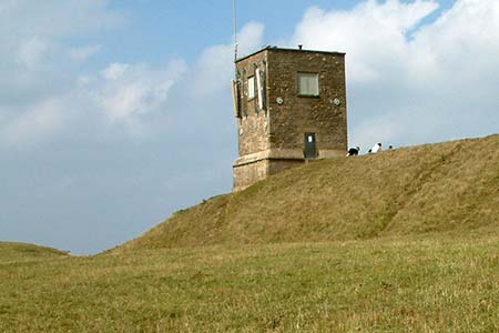
Bredon Hill is an isolated hill with the Severn Valley to the west and the Vale of Evesham to the east. The plateau of the hill is traffic free and offers wonderful views in all directions including the Malvern Hills and the Cotswolds. The summit lies on top of a steep west-facing escarpment and is the site of an Iron Age fort and features a tower and an 'elephant' rock! The walk offers an energetic route which includes significant uphill walking. However, the rewards are relative solitude and some great views. Carrying the relevant map is also recommended as although route finding is generally good, there are a few places where a map will prove to be useful.
The start of the walk is the attractive village of Elmley Castle (grid ref. SO983412) where on street parking is available. However. do park with courtesy and respect local residents access. After parking, walk south along Main Street. At the Queen Elizabeth Inn, turn right into Hill Lane. After 200 metres or so either take the first footpath on the left, which offers a shortcut, or stay on Hill Lane and follow it when it turns sharp left. Continue to climb steadily up Hill Lane passing several attractive half-timbered cottages.
Where the tarmac lanes ends (grid ref. SO973408) continue ahead on a sunken track to reach a gate. Fork right on a clear track and almost immediately bear left on to a narrower track that leads between Fox Hill Wood and Doctor's Wood. Once through the gap, take the gate on the left and follow a rising ill-defined bridleway leading across a field. This leads to the northernmost corner of Long Plantation (grid ref. SO967403). Turn right here onto the Wychavon Way climbing steadily to reach the plateau. The bridleway soon reaches the Iron Age Fort with the adjacent tower. It is worth spending some time here to enjoy the magnificent view to the Malvern Hills.
To continue, walk south west with a wall to your right. Pass through two gates and into a small plantation. In a further 250 metres take the stile on the left and continue past Sundial Farm (grid ref. SO955392) to reach a track after a further 300 metres or so. Turn left along the track and then right into the Belt. After 250 metres turn right down a tarmac lane. This descends gently to reach the road at Overbury after a mile (grid ref. SO960378).
Turn left onto the road and follow it as bends sharp right into Pigeon Lane. When the road bends sharp right (grid ref. SO967377), turn left up a track. After 150 metres turn right and follows this track over the flank of Conderton hill to reach a 'crossroads'. Go straight across soon turning right to a barn (grid ref. SO976376). Just after the barn take the stile on the left. Stay on this path to reach Grafton (grid ref. SO984373). Follow the lane eastwards through this hamlet down to a T-junction (grid ref. SO986371). Turn left.
At the next bend, turn left onto a track and walk uphill for 200 metres. Take the footpath on the right across several fields passing Paris to join the Wychavon Way above the village of Ashton under Hill at grid ref. SO995379. Turn left and follow the Wychavon Way along the northern escarpment of Bredon Hill for just under two miles to reach a four-way junction of bridleways (grid ref. SO973395). Turn right here into the trees and descend passing Fiddler's Knap. At the next fence, cross the stile and take the path heading north to Elmley Castle. This path leads across fields and through the churchyard to join the southern end of Main Street.
Other walks nearby
| Walk 2402 | Bredon Hill from Elmley Castle | easy/mod | 5.5 miles |
| Walk 3637 | Evesham & Haselor Hill from Cropthorne | easy/mod | 8.0 miles |
| Walk 1853 | Bredon Hill from Kemerton | easy/mod | 5.2 miles |
| Walk 3063 | Stanway & Snowshill circular | moderate | 8.0 miles |
| Walk 1355 | Stoulton Circular | easy/mod | 7.5 miles |
| Walk 3072 | Broadway, Stanton & Laverton | easy/mod | 7.5 miles |
| Walk 3250 | The Broadway Tower from Broadway | easy/mod | 5.0 miles |
| Walk 3327 | Temple Guiting & Cutsdean from Stanway | moderate | 10.0 miles |
| Walk 3692 | Egdon, Stoulton & White Ladies Aston | easy | 6.3 miles |
| Walk 2676 | River Severn & Apperley from Tewkesbury | easy/mod | 7.5 miles |
Recommended Books & eBooks
The Cotswold Way
 Guidebook to walking the Cotswold Way National Trail. Between Chipping Campden and Bath, the 102 mile route explores the Cotswolds AONB. Described in both directions over 13 stages, the Cotswold Way can be walked year round and is suitable for beginner trekkers. Includes separate OS 1:25,000 map booklet of the route.
More information
The Cotswold Way Map Booklet
 Map of the 102 mile (163km) Cotswold Way National Trail, between Chipping Camden and Bath. This booklet is included with the Cicerone guidebook to the trail, and shows the full route on OS 1:25,000 maps. The trail typically takes two weeks to walk, and is suitable for walkers at all levels of experience.
More information
Messaging & Social Media
Message Walking Britain and follow the latest news.

Mountain Weather
Stay safe on the mountains with detailed weather forecasts - for iOS devices or for Android devices.