Totridge Fell via Langden & Bleadale Water
Forest of Bowland Walk
Region - Forest of Bowland
County/Area - Lancashire
Author - Paul Heap
Length - 10.0 miles / 16.3 km Ascent - 1270 feet / 385 metres
Time - 6 hours 20 minutes Grade - mod/hard
Maps 

| Ordnance Survey Explorer OL41 | Sheet Map | 1:25k | BUY |
| Anquet OS Explorer OL41 | Digital Map | 1:25k | BUY |
| Ordnance Survey Landranger 102 | Sheet Map | 1:50k | BUY |
| Anquet OS Landranger 102 | Digital Map | 1:50k | BUY |
Walk Route Description
Click image to see photo description.
The Forest of Bowland is one of Lancashire's best kept secrets. With a wonderful mixture of wild and cultivated scenery this walk explores some of the unique character of this Area of Outstanding natural Beauty. As with all moorland and high level excursions this walk should not be attempted by inexperienced walkers in poor weather conditions as leaving Bleadale Water can be disorientating in poor visibility.
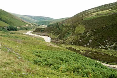
The walk begins from the car park at Dunsop Bridge (Grid ref. SD661501). Leave car park and cross the bridge turning right after the bridge to follow the road past a group of houses. Eventually this becomes a path which continues towards Closes Barn where care needs to be taken as the path seems to be hidden by rubbish and small green houses! Head left towards the wall and you will see a rusting gate. Go through this gate and follow the path across the field down to the road coming out near a cattle grid. Turn right and follow the road for a short distance to Hareden Farm. Cross over the bridge and turn right to see the stile. This path now goes alongside Langden Brook towards the Intake passing Smelt Mill, which is the home to Bowland Pennine Mountain Rescue Team.
Crossing a small footbridge at the Intake follow the path up the valley alongside Langden brook towards Langden Castle (Grid ref. 606503). This is not a castle but a stone hut and its origin is not fully known although some locals have suggested that it was a stop over for guards and prisoners on their way to Lancaster assizes.
From here, the path goes below Sykes Fell into the valley containing Bleadale water. Care should be taken from here, especially in poor visibility. After crossing the brook, which can be difficult in spate, keep to the left-hand side of the valley where a narrow path climbs steadily alongside the stream. Allow plenty of time ascending Bleadale water as it will take much longer than you think. The path gradually rises until you reach the head of Bleadale water near to a small waterfall. Unfortunately from here the path disappears and you need to keep heading due south taking care underfoot because of the hidden holes and the density of the heather. Eventually you will see the fence line, which in bad weather is a welcome sight.
Follow the fence line easterly towards Totridge Fell. Again allow plenty of time as the terrain can be difficult in places. Pass the grouse butts (Grid ref. 624475) shortly after which the fence turns into a wall. Keep the wall to the right hand side for quite some distance and you will eventually come close to the summit of Totridge Fell. To visit the summit you will need to leave the wall and head north east for approximately 100 yards until you reach the actual summit. From here there are some magnificent views of Lancashire and the neighbouring counties.
Leaving Totridge you descend steeply down following the wall until you pick up the main path north west of Mellor Knoll (Grid ref. 644497). Head left towards Hareden Farm and from here it is a simple return to the car park at Dunsop Bridge using the first section of the outward route or alternatively staying with the road.
Other walks nearby
| Walk 2594 | Totridge Fell & Fiendsdale Head, Forest of Bowland | moderate | 11.0 miles |
| Walk 1218 | Fiensdale Head & Bleasdale Water | moderate | 10.0 miles |
| Walk 2384 | Hodder Valley from Whitewell | easy/mod | 6.8 miles |
| Walk 2216 | Slaidburn Village Trail - Ribble Valley | easy | 0.8 miles |
| Walk 3329 | Stocks Reservoir from Slaidburn | moderate | 11.5 miles |
| Walk 2452 | Dunsop Head from Slaidburn | easy/mod | 7.0 miles |
| Walk 3038 | Wolfhole Crag from Tower Lodge | moderate | 9.0 miles |
| Walk 1902 | Saddle Fell, Fair Snape Fell & Parlick from Chipping | moderate | 8.0 miles |
| Walk 2505 | Fair Snape Fell from Fell Foot, Forest of Bowland | moderate | 6.0 miles |
| Walk 3730 | Stocks Reservoir Circular | easy/mod | 7.0 miles |
Recommended Books & eBooks
Walking on the West Pennine Moors
 This guidebook describes 30 walks on the West Pennine Moors, around Blackburn, Darwen, Chorley and Bolton, home to some of the most inspiring and exhilarating walking country. The walks range from short, easy rambles to more challenging hikes covering a variety of terrain, all of it easily accessible for day walking.
More information
Walking in the Forest of Bowland and Pendle
 A guidebook to 40 diverse circular day walks suitable for walkers with navigational skills. The Forest of Bowland and Pendle are two of north west England's upland AONBs, perfect for walkers who enjoy exploring rough hilly, sometimes pathless terrain. The routes include Ward's Stone, Pendle Hill, Longridge Fell and Fair Snape Fell.
More information
Messaging & Social Media
Message Walking Britain and follow the latest news.

Mountain Weather
Stay safe on the mountains with detailed weather forecasts - for iOS devices or for Android devices.