Walk 2511 - printer friendly version
Silverdale & Arnside Walk
Author - Mike Bexley
Length - 8.0 miles / 13 km
Ascent - 1300 feet / 394 metres
Grade - easy/mod
Start - OS grid reference SD471759
Lat 54.176145 + Long -2.81193
Postcode LA5 0UQ (approx. location only)
This is pleasant walk through mature woodlands, which contrast with the Kent Estuary. In addition there are breathtaking views across to the Lake District. An added bonus is an abundance of wildlife with woodland and seabirds and if you are lucky Red Squirrels. Also keep a look out for seals fishing in the tidal streams near the shore.
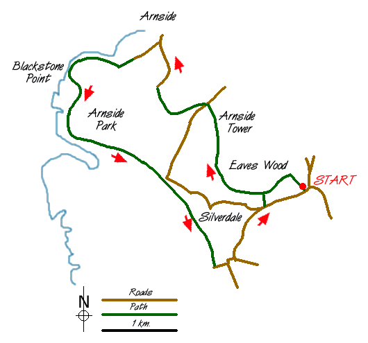
The start is at 'The Park' a small free National Trust Car Park (grid ref. SD471759) on the northern side of Silverdale. Enter Eaves Woods from the car park and follow the footpath. This in turn follows the boundary on the left in a south-westerly direction. Keep to the wider footpath which later follows a high wall on the left. Keep straight on through the woods and open glades turning to a northerly direction until you reach a caravan site.
Drop down into the caravan site crossing the service road and continuing up the grass bank. You will find a path to the right and this drops down to Arnside Tower (Grid ref. 458769). A medieval peel tower it was built as a refuge for the villagers from marauding bands of Scots. From here you can see your onward route, which is over the stile then down to the farm and up their lane to the main road ahead.
At this point there is a gate into the Arnside Knott Woods. Follow the main footpath left. It heads west before turning north into a small car park. Walk through this car park with its distant views of the Lake District. Just before leaving the car park there is a board on the right naming the mountains in the distance. It is worth climbing the hill behind to gain even better views.
Exit the car park over the cattle grid and go down the lane taking the road on the left at the bottom. This road leads to a bridleway down to New Barns (Grid ref. 445778) and the River Kent with the Kent Viaduct to your right. Turn to the left up to the buildings taking note of the warnings regarding quicksand's etc!
You now have a choice of routes - either to go right following the shoreline around Blackstone Point to a bay prior to Arnside Point (Grid ref. 438773) or take the lane to the left which cuts overland through a small campsite to the same bay. We are now walking south.
There is now a further choice although if the tide is in then the choice may be made for you. The first option is to walk along the shoreline whilst the second is to take the high path in the woods, which also follows the shoreline. If you are taking the high path then look for a narrow path towards the end of this bay up into the woods to join the path south, care must be taking on this path as there are steep drops on the right. If your choice is the shore then follow the coastline - notice boards state 'of siren warnings when the tide is coming in'. Luckily there are many places where you can scramble up to the footpath. Just prior to the end of the path, at Hollins Farm Caravan Site drop down to the shore and continue to follow the coastline. Leave the shore at the slipway running down from a metalled road (Grid ref. 457749).
Continue up this road passing The Silverdale Hotel and at the T-junction turn left. Then left again at the top. This road takes you through Silverdale passing shops, cottages and the unique fire station building. Just after a road joins you from the left with a cemetery on the right take the steep footpath left up into the woods. On reaching the footpath in the woods turn right, continue along this path turning right again at the first junction back to the start.
Messaging & Social Media
Message Walking Britain and follow the latest news.

Mountain Weather
Stay safe on the mountains with detailed weather forecasts - for iOS devices or for Android devices.