Chew Reservoir & Fox Stone from Dovestones
Peak District Walk
Nat Park - Peak District - Black Hill Dovestone
County/Area - Greater Manchester
Author - Mike Bexley
Length - 7.5 miles / 12.2 km Ascent - 960 feet / 291 metres
Time - 4 hours 40 minutes Grade - moderate
Maps 

| Ordnance Survey Explorer OL1 | Sheet Map | 1:25k | BUY |
| Anquet OS Explorer OL1 | Digital Map | 1:25k | BUY |
| Ordnance Survey Landranger 110 | Sheet Map | 1:50k | BUY |
| Anquet OS Landranger 110 | Digital Map | 1:50k | BUY |
Walk Route Description
Click image to visit gallery of 2 images.
A Peak Distrcit walk designed to be full of interest with a little bit of easy scrambling, some history and of course good views. The walk can be shortened, as the route back to the start is clearly visible.
Start from Dovestone Reservoir Car Park (Grid ref. SE013034). Walk down Bradbury's Lane, this lane is to the left of the toilet block and you will come to a row cottages, which were built for the workers at Fletcher's Paper Mill, which can be seen in the valley. The cottages were very small, the back of one cottage forming the back of the other, no gap between. They are now enlarged, by breaking through the dividing wall. Also notice the old washing line hooks on posts to the left and to the wall of the cottages on the right so stretching the washing over the lane.
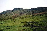
Continue up the lane to turn sharp left at the house into Intake Lane (Grid ref. 002035). This lane, at a higher level, doubles back in the direction you have just come leading you through beautiful meadows and woods. Just after the second woods and some very large boulders, turn right at the stile (Grid ref. 019027) and go straight up Rams Clough keeping to the right of the water course. On reaching the top, Hoarstone Edge, turn left and follow the edge round and up to Chew Reservoir's dam wall (Grid ref. 035018). Chew Reservoir is England's highest reservoir at 1600ft above sea level and was constructed in 1912.
Cross over the dam wall and turn left taking the high ground to the right of the dam service road. The feint path becomes clearer after the deep disused quarry. Keep on this path passing The Dish Stone, a mushroom type stone with a flat top, with the edge on your left and wonderful views ahead. You must visit Bramley's Cot, a small building with an uncertain use and easy to miss. When you reach the point when you can see Fox Stone Cairn ahead look for Bramley's Cot below and to the left of you, it is built into the rocks. After inspecting the Cot return to the path and head for the Fox Stone Cairn on Dovestones Rocks with its tablet in memory of two climbers who lost their lives in the Italian Dolomites (Grid ref. 025037).
You now proceed down towards Dovestones Reservoir. However the route is not obvious. First descend at a 45 degree angle to the right of the Fox Stone towards a area of small stones. Then turn sharp left still gradually descending with the Fox Stone above and to the left. Contour around the edge and follow a clear path down heading for a stile leading to a wide break between the young trees. Go over another stile then left to join the wide path which runs around the Reservoir. Keep left passing the memorial tree enclosure, go over a bridge over a stream. Turn right at the junction towards the yacht club and the start.
Other walks nearby
| Walk 2634 | Broadstone Hill & the Cotton Famine Road | moderate | 7.0 miles |
| Walk 2600 | Chew Reservoir & the Pennine Way | mod/hard | 14.0 miles |
| Walk 2914 | The Pots & Pans from Uppermill | easy/mod | 4.5 miles |
| Walk 3607 | Reservoirs Walk from Tintwistle | easy/mod | 5.5 miles |
| Walk 2521 | Hollingworthall Moor & Walkerwood Reservoirs | moderate | 7.0 miles |
| Walk 1179 | Lad's Leap & Laddow Rocks from Crowden | moderate | 6.5 miles |
| Walk 2621 | Black Hill & Laddow Rocks | moderate | 9.0 miles |
| Walk 3022 | Black Hill | moderate | 9.0 miles |
| Walk 2375 | The Longendale Edges | mod/hard | 11.8 miles |
| Walk 2518 | Black Hill & Four Reservoirs from near Wessenden Head | moderate | 10.0 miles |
Recommended Books & eBooks
Dark Peak Walks
 Guidebook to 40 walks in the Dark Peak area of the Peak District National Park. 35 circular routes for most abilities, from 8km to 19km, around Edale, Marsden, Fairholmes, Baslow and Castleton, including Kinder Scout and Mam Tor, and 5 longer (25km to 45km) routes highlighting the best of the Gritstone Edges, High Moorland and Deep Valleys.
More information
Walking in the Peak District - White Peak East
 Guidebook describing 42 half-day and day walks in the limestone landscapes of Derbyshire's White Peak, part of the Peak District National Park. One of two volumes, this book covers the east of the region, with potential bases including Bakewell, Eyam, Castleton, Birchover, Matlock and Wirksworth.
More information
Messaging & Social Media
Message Walking Britain and follow the latest news.

Mountain Weather
Stay safe on the mountains with detailed weather forecasts - for iOS devices or for Android devices.