Rivington Pike
Lancashire Walk
County/Area - Lancashire
Author - Mike Bexley
Length - 8.0 miles / 13 km Ascent - 1200 feet / 364 metres
Time - 5 hours 10 minutes Grade - moderate
Maps 

| Ordnance Survey Explorer 287 | Sheet Map | 1:25k | BUY |
| Anquet OS Explorer 287 | Digital Map | 1:25k | BUY |
| Ordnance Survey Landranger 109 | Sheet Map | 1:50k | BUY |
| Anquet OS Landranger 109 | Digital Map | 1:50k | BUY |
Walk Route Description
Click image to see photo description.
This is a walk worth travelling to, so close to the M61 (approx 5miles from Junction 6) yet wild, desolate and picturesque. If it's your first visit to this area it will not be your last. The early stages of the walk are within the estate once owned by Lord Leverhulme, who made his wealth from bars of soap. It is thanks to his generosity that we can walk these superb tracks and admire the buildings he created.
The walk starts from Great House Barn car park (Grid ref. SD628139). Leave the car park via the entrance crossing over the road to walk up the wide drive ahead that leads you to Rivington Hall Barn. Continue to walk up the drive to the hall then left of the buildings to the back entrance. Proceed up the bridleway and at a right turn go over the stile ahead and to the left of you. This path ends at a small car park (Grid ref. 638148). It is important here that you select the correct path.
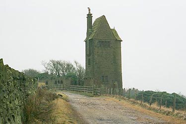
Take the steep stony bridleway opposite the stile, not the lane to the right. This twisting bridleway skirts the woods on the right and climbs south east with wonderful views across Rivington Moor eventually reaching Pigeon Tower (Grid ref. 640143). This tower is situated at the corner of a large terraced garden created by Lord Leverhulme. With its waterfalls, lake and Japanese Garden now overgrown, it is still worth exploring. It is also worth making the detour to climb up to Rivington Pike ahead of you. Proceed along the Rhododendron lined track then up the path on the left to the summit. Return to the tower then turn right along the concessionary track that leads you to the bridleway named Belmont Road. Follow this track skirting Noon Hill and on reaching the road turn right.
A short walk up the road then at the boundary sign turn left along the stony path leading to a stile, keep to the fence. Just before climbing the hill turn left along the well worn path (Grid ref. 654162) to the remains of Higher Hempshaw's, recognised by the wide track coming from the road on your left. You can proceed in the same direction across the moor but I prefer to turn right keeping to the wide track then left again on wide track (Grid ref. 646168). Both paths end at the remains of Simms. Proceed over the stile continuing along the track that drops down to Lead Mines Clough with its information board telling you of the history of this mine. Do not cross over the river here but proceed down river then over a bridge and at the road turn right (Grid ref. 627160). With Yarrow Reservoir on your left, walk along the road turning left at the dam. At first follow the edge of the Reservoir and then on reaching the lane turn right. This lane goes over a small dam with Lower Rivington Reservoir on your right. Turn left at the road then right at the Bridleway sign, passing a school on your left. Keeping to the track ahead, following the Reservoir, you will arrive at your start.
Other walks nearby
| Walk 2245 | Winter Hill & Rivington Pike | easy/mod | 6.0 miles |
| Walk 1850 | Great Hill & Anglezarke Reservoir | moderate | 9.0 miles |
| Walk 2732 | Darwen Tower & West Pennine Moors | easy/mod | 5.5 miles |
| Walk 2108 | Darwen's Jubilee Tower from Abbey Village | easy/mod | 9.0 miles |
| Walk 2584 | Turton & Entwistle and Wayoh Resrs. from Jumbles | moderate | 10.0 miles |
| Walk 2564 | Calf Hey, Ogden & Holden Wood Reservoirs | moderate | 7.5 miles |
| Walk 2624 | Tor Hill & High Moss, Nr Haslingden | moderate | 7.0 miles |
| Walk 1747 | Oswaldtwistle Moor | easy/mod | 6.0 miles |
| Walk 3691 | Scout Moor from Ashworth Moor Reservoir | easy/mod | 4.5 miles |
| Walk 1421 | Turf Moor & Black Hill | moderate | 10.5 miles |
Recommended Books & eBooks
Walking on the West Pennine Moors
 This guidebook describes 30 walks on the West Pennine Moors, around Blackburn, Darwen, Chorley and Bolton, home to some of the most inspiring and exhilarating walking country. The walks range from short, easy rambles to more challenging hikes covering a variety of terrain, all of it easily accessible for day walking.
More information
Messaging & Social Media
Message Walking Britain and follow the latest news.

Mountain Weather
Stay safe on the mountains with detailed weather forecasts - for iOS devices or for Android devices.