Grasmoor and Rannerdale Knotts from Crummock Water
Lake District Walk
Nat Park - Lake District - Lake District North Western Fells
Wainwrights - Eel Crag, Grasmoor, Rannerdale Knotts, Wandope, Whiteless Pike
County/Area - Cumbria
Author - Paul Brown
Length - 8.0 miles / 13 km Ascent - 2880 feet / 873 metres
Time - 6 hours 50 minutes Grade - moderate
Maps 

| Ordnance Survey Explorer OL5 | Sheet Map | 1:25k | BUY |
| Anquet OS Explorer OL5 | Digital Map | 1:25k | BUY |
| Ordnance Survey Landranger 90 | Sheet Map | 1:50k | BUY |
| Anquet OS Landranger 90 | Digital Map | 1:50k | BUY |
Walk Route Description
Click image to visit gallery of 5 images.
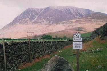
This Lake District walk starts at a small parking area at the foot of Rannerdale Knotts, near Hause Point, on the eastern shore of Crummock Water (NY163183). From here Grasmoor can be seen to the north, the last objective of the route. Head eastward from Hause Point straight up the steep slope of Rannerdale Knotts. The path is not obvious in places and at one stage there is mild scramble up a stony gully to contend with (probably passable by contouring to the south). From the summit of Rannerdale Knotts there are wonderful views over Buttermere to the High Stile range and Fleetwith Pike beyond, and of Whiteless Pike, Grasmoor and Crummock Water, ample compensation for the effort involved.
Continue eastwards along an intermittent path over the easy bumpy ridge of Low Bank to a col (NY179177) before veering left to join a more prominent track up Whiteless Breast and on to Whiteless Pike. The path hereabouts is generally good though occasionally rocky requiring the use of hands as well as feet. It is quite a pull up to the top of the fell, especially on a hot summer's day, but there is an unrivalled view of Grasmoor's southern flank as well as a marvellous panorama. Thirdgill Head Man and Wandope beckon to the north via a nice airy ridge.
The top of Wandope is remarkably flat with Crag Hill - the next objective - and Sail well seen in profile over Addacombe Hole, a spectacular example of a hanging valley. Skirting the edge of this, a prominent sandy path up Crag Hill is soon met leading to the stone trig point on Crag Hill from which a breathtaking prospect of Grisedale Pike and the Skiddaw fells beyond Coledale is revealed.
Leaving the top of Crag Hill, descend to the col between Crag Hill and Grasmoor (NY186203). This area is criss-crossed by several tracks and can be confusing in mist. Continue westward straight across this junction following an eroded path leading up the fellside beyond, which levels out somewhat after a few hundred metres. Walking along the southern flank of Grasmoor there are excellent views down to Buttermere. A short stroll over more or less flat ground gains the undistinguished top of Grasmoor. The Vale of Lorton leading to the Irish Sea extends to the northwest, and the corrugated face of Whiteside over Gasgale Gill is quite remarkable.
Walk back to the top of the Lad Hows ridge approximately 300 metres east of Grasmoor's summit (NY177202) and head down towards Rannerdale. The first section is quite steep though after a few hundred metres the gradient eases as the path veers right and zigzags back to the valley floor to meet another footpath. Turn left here, upstream, into the diminutive Rannerdale valley, crossing Rannerdale Beck via a footbridge (NY168186). Looking back up the valley Whiteless Pike is seen in stark profile, appearing almost conical from this angle. A short stroll though pleasant fields leads back to the parking area.
Other walks nearby
| Walk 1231 | Grasmoor via Whiteless Pike | moderate | 7.0 miles |
| Walk 2020 | Rannerdale Knotts and Crummock Water from Cinderdale Common | easy/mod | 2.5 miles |
| Walk 1142 | Buttermere Circular | easy | 4.5 miles |
| Walk 2609 | Grasmoor via Crag Hill | mod/hard | 8.0 miles |
| Walk 2735 | Fleetwith Pike and Buttermere Circular | mod/hard | 8.5 miles |
| Walk 2642 | Buttermere Horseshoe | very hard | 14.0 miles |
| Walk 2021 | Whiteside, Hopegill Head & Grisedale Pike | moderate | 7.5 miles |
| Walk 1732 | Coledale and Newlands circular from near Buttermere | hard | 9.0 miles |
| Walk 1011 | Knott Rigg and Ard Crags | easy/mod | 3.5 miles |
| Walk 3676 | Hen Comb from Loweswater | moderate | 5.4 miles |
Recommended Books & eBooks
Lake District: Low Level and Lake Walks
 This guidebook describes 30 of the best low-level walks in the Lake District. From delightful wooded glades and sparkling tarns, to waterfalls and glacier-carved valleys towered over by craggy mountains. The walks described aim to seek out the best walking that the lower areas of the Lake District have to offer.
More information
Outdoor Adventures with Children - Lake District
 Guidebook to 40 outdoor adventures in the Lake District with children under 12, including walking, cycling, orienteering, paddling, boating, hostelling and more. Graded activities for varying age ranges or for families with children of different ages.
More information
Messaging & Social Media
Message Walking Britain and follow the latest news.

Mountain Weather
Stay safe on the mountains with detailed weather forecasts - for iOS devices or for Android devices.