Rhinog Fach circular from Coed y Brenin
Snowdonia/Eryri Walk
Nat Park - Snowdonia - Rhinogs
County/Area - Gwynedd
Author - Nick O'Brien
Length - 8.0 miles / 13 km Ascent - 2200 feet / 667 metres
Time - 6 hours 10 minutes Grade - moderate
Walk Route Description
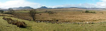
Click image to see photo description.
The Rhinog Mountains are clearly visible from the A470 Dolgellau to Trawsfynydd road and this route approaches these rugged peaks from the east. Travelling north from Dolgellau continue for about 2km past the forest centre and take a left turn (grid ref. 713306) down the minor road. Go through two gates and park immediately at the forest edge (grid ref. SH684302).
After parking follow the left track into the woods for 200 metres to where the track does a sharp left. Leave the track onto a path which brings you to a farm, Graigddu-isaf. The two Rhinog mountains are visible from here with Rhinog Fawr to the right and Rhinog Fach on the left. From the farm follow the track towards Rhinog Fach. This leads to a waymarked footpath which leads up between the two mountains.
After a gentle climb to Bwlch Drws-Ardudwy, which is marked by a large cairn, the path descends into a valley. Where it opens up to a level area look for a stile over a wall on your left (grid ref. 660280). Climb over the stile and follow a steep path through the heather to reach Llyn Cwmhosan a suitable place to pause and take in the view of Rhinog Fawr behind and the summit above.
Stay on this path for the steady climb up to Llyn Hywel with excellent views of Y Llethr and the Cambrian coast. Turn left or south around the lake across the scree and up to the wall where there are even more stunning views across the wild countryside. Go over the wall and follow a visible path north circling the mountain to reach a wall with a stile. Go over the stile and you will soon discover that the path doubles back to the summit of Rhinog Fach.
To descend retrace your steps back to the wall above the Llyn Hywel where you turn east and follow the path down past LLyn y Bi and head for the woods. On reaching the woods careful navigation will take you back to the start.
Maps 

| Ordnance Survey Explorer OL18 | Sheet Map | 1:25k | BUY |
| Anquet OS Explorer OL18 | Digital Map | 1:25k | BUY |
| Ordnance Survey Digital Map Subscription | |||
| Latest Ordnance Survey Discounts | |||
Other walks nearby
| Walk 3227 | Rhinog Fawr and tarns | mod/hard | 15.0 miles |
| Walk 1191 | Rhinog Fawr & Gloyw Lyn from Cwm Bychan | mod/hard | 5.0 miles |
| Walk 1194 | Bwlch Drws-Ardudwy | easy | 4.5 miles |
| Walk 2713 | Traverse of the Northern Rhinogs from Trawsfynydd | mod/hard | 14.0 miles |
| Walk 1173 | Moel Ysgyfarnogod & Foel Penolau | moderate | 6.5 miles |
| Walk 1193 | Y Llethr & Diffwys | mod/hard | 11.5 miles |
| Walk 1746 | Bwlch y Rhiwgyr & Pont Scethin | moderate | 9.8 miles |
| Walk 1646 | The Precipice Walk | easy | 3.5 miles |
| Walk 2811 | Rhobell Fawr and Ddualt from near Rhydymain | moderate | 8.5 miles |
| Walk 1499 | Rhobell Fawr and Dduallt from Llanfachreth | moderate | 12.0 miles |
Recommended Books & eBooks
The Wales Coast Path
 A single guidebook to walking the whole Wales Coast Path - 1400km (870 miles) the length of Wales from Chester to Chepstow, including Anglesey, described in 57 stages. The route passes through the Snowdonia and Pembrokeshire National Parks and many AONBs and can be linked with the Offa's Dyke Path for a complete circuit of Wales.
More information
Mountain Walking in Snowdonia
 Guidebook to 40 of Snowdonia's best day walks, with routes up Snowdon and Tryfan, including the Snowdon Horseshoe, Cadair Idris, Y Garn and The Rhinogs. The routes range from Grade 1 scrambles like Crib Goch or Bristly Ridge, to riverside and forest walks. Includes details of a 2-day traverse of all 15 of Snowdonia's 3000ft peaks.
More information
