Walk 2548 - printer friendly version
Stanage Edge from Hathersage Walk
Author - Nick O'Brien
Length - 8.5 miles / 13.8 km
Ascent - 1600 feet / 485 metres
Grade - moderate
Start - OS grid reference SK231815
Lat 53.329915 + Long -1.6546129
Postcode S32 1HA (approx. location only)
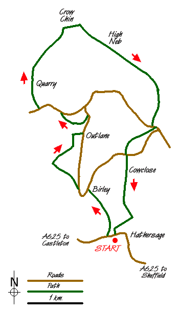
This Peak District walk is aimed at those who may not have their own transport and starts from the busy little village of Hathersage, which is served by bus and rail services. The route wanders north through farmland onto the moors before climbing up onto the Stanage Edge escarpment. On the way back we visit the grave of Little John, one of Robin Hood's men.
Start in the village of Hathersage (Grid ref. SK231815) heading north alongside the river to the footbridge. Cross over the river and walk diagonally up the fields through the woods to Birley Farm (Grid ref. 226824). From here follow the direction signs to the right of the buildings to reach the road. Turn left on the road then left again at the footpath down to Nether Hurst (Grid ref. 222828). Take the left bridleway to Hurstclough Lane turning right to Gatehouse. Just before reaching Gatehouse Farm take the footpath on the left that heads north up the fields. You can continue to proceed all the way up the fields but the path is unclear and often fenced, so I turn right at the path junction to the visible buildings of Outlane (Grid ref. 225836).
On reaching the road at Outlane, turn left, then left again at the path sign. This high path at first doubles back then sweeps round, northwest, through the woods to join the road (Grid ref. 220840). Turn left along the road then right at the footpath climbing up to a disused quarry. Exit north. The footpath starts clearly but tends to become feint and overgrown as you proceed across Bamford Moor. In low cloud a compass is a necessary. Keep heading north until you reach the remains of a wall, then Northeast to the cliff face of Stanage Edge. Head for the lowest and easiest place to ascend, Crow Chin (grid ref 224856), to the left of the high visible rocks of High Neb.
On reaching the top, turn right (south east) keeping to the magnificent edge then descending right at the 'Long Causeway' path junction (grid ref 238846). The path drops down through woods and a car park to the road. Turn left along the road, then right at the footpath just after the low building. The path descends (ignore the gated private path on the left down to the brook) via North Lees to the road (Grid ref. 234831). Turn left passing the farm drive to the high path on the right. Head straight on south following the fence to pass Cowclose (Grid ref. 234829) until the path descends down a field to join a path from the right.
Turn left over the brook climbing up to the church. Little John's grave is in the churchyard to the left (east) of the church. Keep to the path that passes the grave through the church grounds turning right just after the exit. The path follows the wall on the right, down to a lane. Turn left into Hathersage and the starting point.
Messaging & Social Media
Message Walking Britain and follow the latest news.

Mountain Weather
Stay safe on the mountains with detailed weather forecasts - for iOS devices or for Android devices.