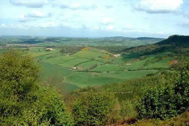
Rievaulx Abbey from Kilburn, near Thirsk
North York Moors Walk
Nat Park - North York Moors - North York Moors West
County/Area - North Yorkshire
Author - Chris Gill
Length - 15.0 miles / 24.4 km Ascent - 2200 feet / 667 metres
Time - 9 hours 40 minutes Grade - mod/hard
Maps 

| Ordnance Survey Explorer OL26 | Sheet Map | 1:25k | BUY |
| Anquet OS Explorer OL26 | Digital Map | 1:25k | BUY |
| Ordnance Survey Landranger 94 | Sheet Map | 1:50k | BUY |
| Anquet OS Landranger 94 | Digital Map | 1:50k | BUY |
Walk Route Description
Click image to visit gallery of 3 images.
This North York Moors walk starts at the car park (grid ref SE516810) just below the White Horse and follows a varied route through fields and woods. The car park can be very busy on nice weekends so it is worth getting there early. The best times to tackle the walk are in spring and summer.
From the car park, I usually take the obvious track that runs west through the woods from the corner of the car park. The path undulates for about 1 km. before climbing steeply beside a fence to emerge on the bridle way at the edge of the glider club field. On a good day there can be quite a lot of activity here, particularly in the afternoon.
Continue north for about 0.75 km, turning right at the Cleveland Way sign on the right. This emerges at a road junction opposite a wide track. Cross the trunk road onto the track and follow this until you find a sign on the right. This narrow and meandering track comes out at Hambleton House riding stable. The path runs along the side of a field and then along the edge of woods until it turns left across fields. Follow this, turning right then left, until it meets the road at the edge of Cold Kirby.
Turn right through the quiet village and continue straight to the far end (ignore the signed path through a garden on the left). The path follows a wall around the side of the last farm and comes to a ladder stile into the field on the left. The route here may be unclear but is diagonally to the right. You should come to a simple stile across the fence. Turn left and follow the fence and over two more stiles. Once again the path may be unclear and is diagonally to the right, crossing another stile until you come to a gate between trees.
Follow the track down to a small road and straight on up to another road. Turn right here and follow this road, which is usually quiet, until you come to Old Byland. Opposite the road junction on the left is a gate and signpost on the right with a track running down at the edge of the woods. The path turns left and descends through the woods until it reaches the valley floor. In places the path is a little boggy but it's a very pleasant walk through woods and past a pheasant run (it was built to house around 2000 birds) and alongside a small stream until you reach a narrow concrete road.
Here you have a choice. My preference is to keep on, initially with the stream on the left but crossing it after 5 or 10 minutes. Again the path can be boggy but it's a nice detour which emerges at a road. Here I turn left, doubling back up hill until I come to the top end of the concrete road. You could, of course turn left when you first meet the concrete road and cut out about 2 km.
A little further up the road is a farm track on the right. This leads down through the woods until it meets a bridle way. Turn right here and then left and over the bridge. The river is the Rye and Ryedale (upstream) is well worth exploring. To the right is the ruin of Rievaulx Abbey (a Cistercian abbey). The path turns uphill a little way and then right through a gate and across fields to emerge in the village of Rievaulx. Turn right here and follow the road to the abbey.
The route onwards continues along the road to a T junction. If you fancy a 10 km. (6 mile) detour you can turn left and follow the Cleveland Way to Helmsley and back.
Turn right at the junction and cross a bridge. Have a look at the garden on your right here and look back to the hill behind the abbey and the Tuscan Temple at the top. Follow the road for 1 km. until it swings left. The Cleveland Way turns right here through a gate. On the right are three large man-made ponds but you soon come to a 4-way track junction. Turn right across the stepping-stones and left through the gate although on a warm day this is a good place to stop for a while.
Follow the bridle way along the level (not uphill on the left) and bear left until you come to a path junction. The Cleveland Way turns right here and uphill. This route takes you back to Cold Kirby from where you retrace your earlier route until you meet the woods again. But there is also a path that continues along the valley floor until it meets a path crossing. This is not easy to spot but turning right brings you to Cold Kirby again.
It is possible to keep straight on even though it looks impassable in places. I'm not sure of the status of this path - it is well used but is not shown as a right of way on my map. Nevertheless, it swings right and uphill until it comes to the point where the path from Cold Kirby reaches the woods.
Follow the path back past Hambleton House to the large track and turn left. On the right is a sign and you can follow this on a meandering detour to the Visitor Centre for a break. On the way back I usually keep to the top path past the white horse and then down the steps to the car park. On a good day there is usually an ice-cream van when you get there!
Other walks nearby
| Walk 1498 | Kilburn White Horse, Cold Kirby, Murton, & Sutton Bank | moderate | 14.0 miles |
| Walk 3581 | Gormire Lake from Sutton Bank National Park Centre | easy/mod | 3.4 miles |
| Walk 1524 | Cold Kirby, Rievaulx Bridge & Wass | moderate | 12.5 miles |
| Walk 2702 | Ampleforth, Shallow Dale, Yearsley Moor & Wilderness | moderate | 9.5 miles |
| Walk 1525 | Beck Dale & Rievaulx from Helmsley | moderate | 9.8 miles |
| Walk 1704 | Oswaldkirk, Nunnington & Harome circular | moderate | 11.5 miles |
| Walk 1622 | Hawnby, Bilsdale West and Wetherhouse Moors | moderate | 8.3 miles |
| Walk 1920 | Rievaulx Moor from Cowhouse Bank | moderate | 9.5 miles |
| Walk 1473 | Hollin Hill to Square Corner by the Cleveland Way | moderate | 9.5 miles |
| Walk 1497 | High Paradise around Arden Great Moor from Square Corner | moderate | 14.3 miles |
Recommended Books & eBooks
Trail and Fell Running in the Yorkshire Dales
 Guidebook to 40 of the best trail and fell runs in the Yorkshire Dales National Park. Ranging from 5 to 24 miles, the graded runs start from bases such as Ribblehead, Dent, Sedbergh, Malham and Grassington and take in the region's diverse delights, from castles and waterfalls to iconic mountains such as Whernside, Ingleborough and Pen Y Ghent.
More information
The Cleveland Way Map Booklet
 Map booklet of the Cleveland Way National Trail, a 177km (110 mile) walk around the North York Moors National Park. This booklet is included with the Cicerone guidebook to the Cleveland Way and the Yorkshire Wolds Way, and shows the full route of the Cleveland Way on Ordnance Survey 1:25,000 maps.
More information
Messaging & Social Media
Message Walking Britain and follow the latest news.

Mountain Weather
Stay safe on the mountains with detailed weather forecasts - for iOS devices or for Android devices.