Walk 2570 - printer friendly version
Cadair Idris from Llanfihangel-y-pennant Walk
Author - Lou Johnson
Length - 10.0 miles / 16.3 km
Ascent - 3500 feet / 1061 metres
Grade - mod/hard
Start - OS grid reference SH673095
Lat 52.666921 + Long -3.9637514
Postcode LL36 9TU (approx. location only)
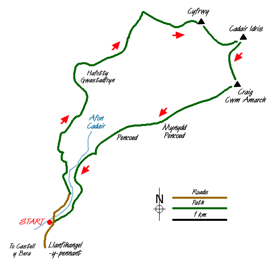
Cadair Idris is a great mountain and sees many visitors to its fine summit each year. Most walkers use either the pony path from the north or the southern approach using the Minffordd path. This route starts near the village of Llanfihangel-y-pennant and climbs steadily on the southern section of the pony path and descends by a less well-known route back to the start.
Limited parking is available on the verge just before the bridge over the Afon Cadair (Grid ref. SH673095) or in the village carpark at Llanfihangel-y-pennant which adds a little extra mileage to the walk. Cross the bridge over the Afon Cadair and bear right following the track signed to Cadair Idris. This climbs steadily up the valley to reach a ford just past Hafotty Gwastadfryn from where the route steepens briefly before easing for the climb up to the col east of Carnedd Lwyd. From here the views open out and you get a grand panorama looking north.
Turn right at the Col to follow the clear path rising towards the summit of Cadair Idris. At the first clear junction bear left to take the secondary path to the summit of Cyfrwy from where there is an excellent view down to Llyn y Gadair far below. Keeping the steep drop into the cwm on your left continue to the summit of Cadair Idris with its trig point and stone shelter.
Descend south west with Llyn Cau below you on your left following the upper stages of the Minffordd path to reach a col. A steep climb takes you onto the summit of Craig Cwm Amarch. Using the fence as a guide walk just south of west following the crest of a clearly defined ridge to Mynydd Pencoed. Maintaining the same line descend for a short way until the ground steepens and then trend right to the small farm buildings at Pencoed (Grid ref. 685111). Be careful however of the steep ground and hidden crags. Also note that this section of the route is not shown as footpath on maps even though there is evidence of one on the ground.
Reaching Pencoed locate the footpath marked on the OS Outdoor Leisure map and descend through fields to join a track. Turn left and follow this back to the road and the start.
Messaging & Social Media
Message Walking Britain and follow the latest news.

Mountain Weather
Stay safe on the mountains with detailed weather forecasts - for iOS devices or for Android devices.