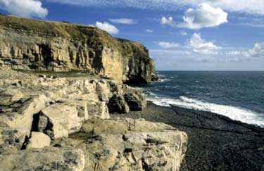
Purbeck Coast from Swanage
Jurassic Coast Walk
Region - Jurassic Coast
County/Area - Dorset
Author - Reg Carr
Length - 10.0 miles / 16.3 km Ascent - 1600 feet / 485 metres
Time - 6 hours 40 minutes Grade - moderate
Maps 

| Ordnance Survey Explorer OL15 | Sheet Map | 1:25k | BUY |
| Anquet OS Explorer OL15 | Digital Map | 1:25k | BUY |
| Ordnance Survey Landranger 195 | Sheet Map | 1:50k | BUY |
| Anquet OS Landranger 195 | Digital Map | 1:50k | BUY |
Walk Route Description
Click image to see photo description.
From Swanage harbour follow signs to Durlston Country Park (Grid ref. SZ035773). From the car park walk to Durlston Head Castle to see the Great Globe weighing 40 tons which is a testament to the mason's art. Follow the path to Tilly Whim Caves and Anvil Point Lighthouse.
Continue along the coast path, enjoying the superb views on the way to Dancing Ledge (Grid ref. SY998769), which is a good picnic spot. There was quarrying of Purbeck Stone all along this coast. At Dancing Ledge there is also a small swimming pool blasted out of the rocks. The spot is also very popular with climbers.
Continue along the coast path past quarries at Seacombe Cliff (Grid ref. SY985766) and Winspit (Grid ref. SY977761). These are also good picnic spots and great places to watch the sea crash against the cliffs on stormy days. Turn inland at Winspit on the path to Worth Matravers (Grid ref. SY975775). This was a quarrying village hence the name of the pub -'The Square and Compass'.
Take the Langton Matravers road out of the village and after about 400 metres turn right onto the path known as the 'Priest's Way'. This route gives you some good examples of Purbeck Stone quarries. Follow this to near Belle Vue Farm (Grid ref. SZ016783) then turn south on the track leading back to the coast. When you reach the steep slope down to the sea you will see a path crossing ahead (Grid ref. SZ016772). Turn left (east) onto this path which heads back across Round Down towards Anvil Point picking up the main path back to the Durlston Country Park car park.
Other walks nearby
| Walk 3286 | Dancing Ledge & Durlston Head from Langton Matravers | easy/mod | 7.0 miles |
| Walk 1634 | Old Harry & Ballard Down from Studland | easy/mod | 5.3 miles |
| Walk 3396 | Agglestone & Old Harry Rocks | easy/mod | 6.4 miles |
| Walk 2925 | St Aldhelm's Head near Worth Matravers | easy | 4.1 miles |
| Walk 1613 | Studland & Old Harry Rocks | easy/mod | 8.5 miles |
| Walk 2145 | Houns-tout Cliff from Kingston | easy | 3.5 miles |
| Walk 1331 | Kimmeridge & Tyneham | easy/mod | 6.8 miles |
| Walk 1534 | Swyre Head & Tyneham Cap from Kimmeridge | moderate | 11.8 miles |
| Walk 1995 | Houns-tout & Swyre Head from Kimmeridge | moderate | 8.7 miles |
| Walk 2568 | Egmont Point & Kimmeridge Bay from Tyneham | moderate | 14.0 miles |
Recommended Books & eBooks
The South West Coast Path
 Guidebook to walking the entire South West Coast Path National Trail. The route runs for 630 miles from Minehead to Poole along the north Devon, Cornish, south Devon and Dorset coastline. Divided into 45 stages, this long-distance coastal trek could be completed within 4 weeks, or walked in sections. Guide includes maps and essential information.
More information
South West Coast Path Map Booklet - Minehead to St Ives
 Map of the northern section of the 630 mile (1014km) South West Coast Path National Trail. Covers the trail from Minehead to St Ives along the north Devon and Cornish coastline. This convenient and compact booklet of Ordnance Survey 1:25,000 maps shows the route, providing all of the mapping you need to walk the trail in either direction.
More information
Messaging & Social Media
Message Walking Britain and follow the latest news.

Mountain Weather
Stay safe on the mountains with detailed weather forecasts - for iOS devices or for Android devices.