Merrick from Glen Trool
Dumfries and Galloway Walk
County/Area - Dumfries and Galloway
Author - David Neale
Length - 8.0 miles / 13 km Ascent - 2600 feet / 788 metres
Time - 6 hours 40 minutes Grade - mod/hard
Maps 

| Ordnance Survey Explorer 318 | Sheet Map | 1:25k | BUY |
| Anquet OS Explorer 318 | Digital Map | 1:25k | BUY |
| Ordnance Survey Landranger 77 | Sheet Map | 1:50k | BUY |
| Anquet OS Landranger 77 | Digital Map | 1:50k | BUY |
Walk Route Description
Click image to visit gallery of 3 images.
Despite being the highest summit in the Southern Uplands of Scotland, an ascent of Merrick is not difficult. The start is at the large car park (grid ref. NX415804) above Loch Trool which provides "water interest" in a glen often compared with the Trossachs.
The route to Merrick is well signposted and goes off north opposite Bruce's stone. The next few miles provide some of the finest scenery to be enjoyed in the Southern Uplands although it must be stressed that it is not highland in character having its own qualities and charm.
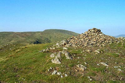
The initial section of the route follows a good path with the Buchan Burn on your right. There are good retrospective views back across the Glen as you gradually gain height. After negotiating a stile, take care to follow the higher route. This leads through the forest to reach the ruined cottage at Culsharg. From here a path follows the right hand side of a dyke by the burn. This leads without problem to the summit of Benyellary, which is marked by a cairn.
The continuation takes you onto Merrick across a broad col known as the "Neive of the Spit". Underfoot the ground is grassy and despite appearances the summit of Merrick with its large cairn is soon reached. In poor visibility do check on the map as there is some steep ground between the two summits and this needs to be avoided.
Merrick's summit offers a superb view resulting from its height and location. The return route follows that used for the ascent although there are other options that can be devised if you are a competent map reader.
Other walks nearby
| Walk 2068 | Maxwell's Otter and Monreith Beach | easy | 6.0 miles |
| Walk 2658 | The Machars Peninsula - St Ninian's Cave | easy | 2.0 miles |
| Walk 3316 | Rockcliffe to Kippford | easy | 3.0 miles |
| Walk 3290 | Rockcliffe to Sandyhills | easy/mod | 5.0 miles |
| Walk 1718 | Mull of Galloway circular | easy | 6.0 miles |
| Walk 2135 | Camps Reservoir Circular | easy | 5.8 miles |
| Walk 2268 | Annandale Way | moderate | 9.0 miles |
| Walk 2050 | The Crown of Scotland | moderate | 9.0 miles |
| Walk 2035 | Hart Fell via Hartfell Spa | moderate | 7.2 miles |
| Walk 2280 | Hart Fell & Whitehope Heights | moderate | 8.4 miles |
Recommended Books & eBooks
No suggestions for this area.Messaging & Social Media
Message Walking Britain and follow the latest news.

Mountain Weather
Stay safe on the mountains with detailed weather forecasts - for iOS devices or for Android devices.