Walk 2640 - printer friendly version
The Storr & Old Man of Storr Walk
Author - Stephen Boulton
Length - 5.5 miles / 8.9 km
Ascent - 2500 feet / 758 metres
Grade - moderate
Start - OS grid reference NG509529
Lat 57.497604 + Long -6.1592590
Postcode IV51 9HX (approx. location only)
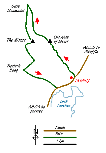
The Old Man of Storr rises to 535 metres and is visible from the main road between Portree and Staffin on the west coast of Skye. Dominating the scene and visible from many more parts of the islands the Storr is the hill immediately west of the Old Man and rising to 719 metres with dramatic cliffs on its eastern flank.
There is a small car park opposite Loch Leathan (Grid ref. NG509529) on the west side of the A855 heading north from Portree to Staffin. From here a refurbished path leads up through the woods to emerge below the Old Man of Storr.
You can scramble up to the base of the Old Man, although the heavily eroded slopes leading up to it suggest you would not be the first person to do so. The rock architecture is superb, lots of pinnacles backed by the imposing cliffs of The Storr. To reach the summit of The Storr we walked north, contouring across the top of Coire Scamadal to a point at about grid ref. NG 494553, whereupon we turned back on ourselves to head south across the easy, grassy rise to The Storr's summit cairn.
A short walk east from the trig point takes you to the cliff edge and a wonderful view over the pinnacles below and out over Loch Leathan and over Dun Caan on Raasay and further to the mainland. On the day we were there you could clearly make out the Five Sisters of Kintail.
From the summit we walked west south west for a hundred metres or so to avoid the top of an obvious gully (might not be so obvious in the mist or snow though), then turned south and then south east to follow the rim of Coire Faoin with the Old Man coming into view again as we descended.
At Bealach Beag we picked up a burn and followed this down through the crags at about grid ref. NG 493531 (steep in places, probably not very easy in snow & ice) to emerge on grassy land which we followed to a stile in the fence by the road at about grid ref NG 503525. From there we turned left and it was a short walk of about 600 metres or so back to the car park. A fine day out.
Messaging & Social Media
Message Walking Britain and follow the latest news.

Mountain Weather
Stay safe on the mountains with detailed weather forecasts - for iOS devices or for Android devices.