Walk 2647 - printer friendly version
Fan Gyhirych, Fan Nedd & Fan Bwlch Chwyth Walk
Author - Hugh Maguire
Length - 10.0 miles / 16.3 km
Ascent - 2200 feet / 667 metres
Grade - moderate
Start - OS grid reference SN896222
Lat 51.88739 + Long -3.6055316
Postcode LD3 8YY (approx. location only)
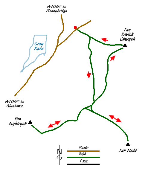
The area immediately west of A4067 near Cray Reservoir offers some excellent hill walking. This walk, walk 2645 and walk 2646 are based on the same starting point are variations on a theme.
Take the road leading north east from the A4067 opposite the Cray Resevoir. The walks) starts on a track on the right just over half a mile along this road (Grid ref. SN 896222). There is quite a bit of parking space at the start of the track but keep away from the gate as this is sometimes used by lorries visiting the quarry further up the track.
This walk offers no navigational problems and involves following the track (don't take the LH fork) for several miles until it starts to descend at which point you walk north west for a short distance to the trig point on Fan Gyhirych (Grid ref. SN 880190). This a good place for a break with spectacular views. Although the track climbs all the way it is actually quite easy walking.
Descend the track used on the ascent and at about grid ref. SN 900196 branch right onto another track. Follow it and head south east. You can see Fan Nedd in front of you as you drop downhill into a bit of boggy area. You then follow the track up Fan Nedd to the top (Grid ref. SN 913183). Once again a good place to stop with excellent views.
Return to the main track and then bear north and then east along the ridge to the trig point on Fan Bwlch Chwyth (Grid ref. SN 912216). From here walk just north of west back to the start. This last bit can be a bit harder, crossing the stream's deep valley, but is still ok.
Messaging & Social Media
Message Walking Britain and follow the latest news.

Mountain Weather
Stay safe on the mountains with detailed weather forecasts - for iOS devices or for Android devices.