Photographer's Kentmere Horseshoe
Lake District Walk
Nat Park - Lake District - Lake District Far Eastern Fells
Wainwrights - Froswick, Harter Fell, Kentmere Pike, Ill Bell, Mardale Ill Bell, Shipman Knotts, Yoke
County/Area - Cumbria
Author - Stephen Starkey
Length - 13.5 miles / 21.9 km Ascent - 3700 feet / 1121 metres
Time - 10 hours 30 minutes Grade - mod/hard
Maps 

| Ordnance Survey Explorer OL7 | Sheet Map | 1:25k | BUY |
| Anquet OS Explorer OL7 | Digital Map | 1:25k | BUY |
| Ordnance Survey Landranger 90 | Sheet Map | 1:50k | BUY |
| Anquet OS Landranger 90 | Digital Map | 1:50k | BUY |
Walk Route Description
Click image to visit gallery of 3 images.
The Kentmere Horseshoe is one of the classic Lake District horseshoe walks. Being in the Far East of the Lake District National Park, is easier to access than most, making it a possibility for walking at any time of year. Traditionally the route is done as a clockwise circuit from Kentmere. Whilst there is nothing wrong with this approach, and it will offer spectacular photography opportunities of the Lakeland Fells to the West, walking the route anti-clockwise will give the photographer much better lighting of the fells that make up the route. This variation of the horseshoe is 21.8km (13.5 miles) long and involves 1,130m (3,700ft) of ascent and descent. Depending upon how often you stop to use your camera, allow between 7 and 8.5 hours for this route.
When to walk - some sections of this route will involve negotiating peat bogs. As with many areas in the Lake District, a bright, clear day adds greatly to the beauty of the walk. Providing you are comfortable with the possibility of walking across snow / ice, I would strongly recommend doing this walk on a crisp, clear day in January / February after a cold snap. The air is generally cleaner and clearer on such days in winter than on sunny summer days and there is a reasonable chance of the bogs being frozen so that you can walk across them with ease and confidence, and, more importantly, dry feet. Parking is limited in Kentmere but has improved with two fields being offered for parking for a small fee!
The Route - Assuming you are able to park at the village hall (about 6 spaces), take either of the paths alongside Kentmere Church that lead down to the River Kent and cross the river by means of the footbridge. From the footbridge take the visible path up hill across the field to cross Low Lane via the stone step stiles built in to the walls on both sides of the lane.
The path then leads out on to a minor road (High Lane). Turn left along the road for about 400m to a small gravelled area often used as an impromptu car park despite the no parking signs. Here you take the signed footpath leading off to the right. The path climbs very gently along a pleasant lane for 1.3 km until you arrive at the second 6 bar gate, with another gate on the right and a path leading off up hill to the left. Turn left on to the path and follow it to climb steadily uphill, steeply in places. The path stays close to a wall on the right as it ascends through the crags to eventually reach the summit of Shipman Knotts.
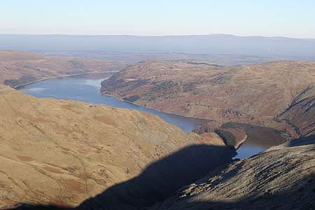
From here there are views to the West across the valley to the peaks of Yoke, Ill Bell and Froswick that form the return route; to the East the view takes in Sleddale Fell, Grey Crag, Buckbarrow Crag and Tarn Crag. For now the route is to follow the reasonably obvious path on the lengthy but easy climb of Kentmere Pike. The views on the left open up to include Kentmere Reservoir but to get the best Easterly views from Kentmere Pike, it is necessary to cross the summit stile, pass the OS trig point and wander (carefully) to the edge for the views to Grey Crag, Tarn Crag etc.
From Kentmere Pike, continue ahead, following the same path that hugs the fence / wall. This takes you across great expanses of moorland that is quite boggy in places. The fence kinks left and right in a few places. At 458-086 when the fence kinks to the right, look for and follow a grass path heading half left away from the main path, passing above Drygrove Gill. It's not the end of the world if you miss the path - all it does is cut out about 40m further ascent to the amazingly unspectacular summit of Harter Fell and the resultant 40m descent; though Wainwright Baggers may well opt to tick off another peak on the list.
The grass path traverses the slopes of Harter Fell to eventually merge with the main path descending from the summit. Continue descending along the main path to reach the interesting stone shelter at Nan Bield Pass. If necessary, turning left at the shelter will provide an escape route down the valley past Kentmere Reservoir back to Kentmere village. The main route though continues ahead to climb, steeply at first, through the rocky crags to the summit of Mardale Ill Bell. Although this section of the route is rocky in places, route finding is never difficult.
From Mardale Ill Bell there are terrific views over Haweswater to the North. Given anything other than a 'pea-souper' of a day, the direct route to the impressive Thornthwaite Beacon is clear from the summit of Mardale Ill Bell. However, a better route is to descend to the South West on a grid bearing of 230 to pick up the path around the head of the Kentmere Valley that gives spectacular views down the valley in places. This path eventually merges with another path from the right at an unusual marker post. Wainwright Baggers and photographers alike may well want to turn back to the right for the short climb to the summit of Thornthwaite Crag and the huge, impressive, stone built beacon. Irrespective of whether or not the detour to Thornthwaite Beacon is taken, the path heading South on to the ridge West of Kentmere Valley is clearly visible.
The return route involves walking the full length of this impressive ridge, taking in the summits of Froswick, Ill Bell and Yoke along the way. The ridge path is undulating but does not involve any major loss / gain of height. However, some of the climbs, although short, are quite tough. To the right (West), a clear day will afford wonderful panoramic views including the Helvellyn range, Langdale Pikes, Windermere and Coniston Fells. On a very clear day, the panorama also includes Blackpool Tower, Yorkshire Dales and the Howgills.
The view from Ill Bell, including the three distinctive cairns and Windermere makes for great photos. The descent from Yoke is straightforward with route finding presenting no difficulties. There former choice of paths on the section beyond the wall has been made easier with substantial path improvements using crushed stone. All you need to do is follow the path to a junction with the Garburn Pass.
Here you turn left for a descent along a stony bridleway. Although the stony bridleway may come as a relief after any bogs encountered on the descent from Yoke, this section can be treacherous in places if undertaken on a winter day with sub-zero temperatures. The Garburn Pass path emerges on to a minor road at The Nook from where it is simply a case of following the road to the left for 400m to return to the car.
Other walks nearby
| Walk 2488 | Shipman Knotts & Kentmere Pike | moderate | 6.2 miles |
| Walk 1147 | Longsleddale and Kentmere Pike | moderate | 8.0 miles |
| Walk 3033 | Tarn Crag & Harrop Pike from Sadgill | moderate | 5.5 miles |
| Walk 1463 | School Knott & Grandsire from Ings | easy/mod | 6.5 miles |
| Walk 2464 | Kentmere Valley Circular | moderate | 10.0 miles |
| Walk 1049 | Staveley Tarns circular | easy/mod | 6.0 miles |
| Walk 1555 | Brunt Knott from Staveley | easy/mod | 7.0 miles |
| Walk 1109 | Harter Fell & Nan Bield Pass | moderate | 4.5 miles |
| Walk 1269 | High Street & Kidsty Pike | moderate | 7.5 miles |
| Walk 1462 | Mardale Head horseshoe | moderate | 8.0 miles |
Recommended Books & eBooks
Great Mountain Days in the Lake District
 An inspirational guidebook to 50 challenging walks on the high fells of the Lake District. The graded circular routes, between 4 and 14 miles in length, cover classic Lakeland summits like Fairfield, Scafell Pike, Great Gable and Blencathra, to the lesser-known High Spy, King's How and Brund Fell.
More information
Walking the Lake District Fells - Buttermere
 Part of the Walking the Lake District Fells series, this guidebook covers a wide range of routes to 32 Lakeland summits that can be climbed from the Buttermere, Lorton and Newlands valleys, with highlights including Haystacks, High Stile, Grasmoor and the fells of the Coledale Round. Suggestions for longer ridge routes are also included.
More information
Messaging & Social Media
Message Walking Britain and follow the latest news.

Mountain Weather
Stay safe on the mountains with detailed weather forecasts - for iOS devices or for Android devices.