Walk 2659 - printer friendly version
Conic Hill Walk
Author - Lou Johnson
Length - 4.0 miles / 6.5 km
Ascent - 1400 feet / 424 metres
Grade - easy/mod
Start - OS grid reference NS420909
Lat 56.084712 + Long -4.5407358
Postcode G63 0JQ (approx. location only)
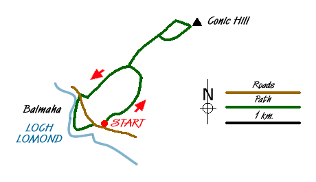
Loch Lomond is one of the scenic jewels of Scotland. This walk enables you to enjoy some excellent views of the lake both from above and from the lochside. Using a section of the West Highland Way the way does involve some uphill work but the views compensate for the effort. Conic Hill is the summit of ridge consisting of a number of rounded hills made from puddingstone (conglomerate).
The start is the large and free car park (at least in 2009!) by the Loch Lomond and Trossachs National Park Visitor Centre (toilets) on the east side of the B837 road at Balmaha (grid ref. NS420909). The car park is also served by buses from Balloch railway station which has frequent direct trains from Glasgow. The walk starts at the back of the car park where you should locate the West Highland Way. This is followed back towards Milngavie. Initially the path passes through woodland but soon emerges into more open country on the eastern flank of the Conic Hill ridge.
The climb starts in earnest here and you soon arrive at an open col, Bealach Ard. The path bears right and now on the opposite flank of the hill continues its uphill progress still following the West Highland Way. After just over 600 metres, look out for a steeper path veering right. This climbs to what seems to be the accepted summit of Conic Hill. It is not the highest point but probably offers the best view west over Loch Lomond and a nice background panorama of mountains. Also in view to the north is Ben Lomond.
To reach the highest point, leave the popular summit and continue northeast parallel to the West Highland Way. Descend to a col, go over a minor 'lump' to another col and then climb to true summit. The view is not much different but you can enjoy the peace and quiet or perhaps have a picnic without throngs of people.
To descend return to the last col. Instead of going over the minor 'lump' bear right and descend to the West Highland Way. Go left on this National Trail and continue to descend as far as Bealach Ard. Instead of taking the WHW directly to the car park at Balmaha, veer 10 metres or so to your right and continue along the obvious grassy ridge. There is a path and this leads you to the end of the ridge. The path descends steeply and leads out onto the road.
Cross the road to the lochside and follow the clear path keeping Loch Lomond of your right. You have the option of staying level with the loch or clambering up to the viewpoint of Craigie Fort. Whichever option you take the routes rejoin and lead you back to the centre of Balmaha where there are refreshments in season.
Messaging & Social Media
Message Walking Britain and follow the latest news.

Mountain Weather
Stay safe on the mountains with detailed weather forecasts - for iOS devices or for Android devices.