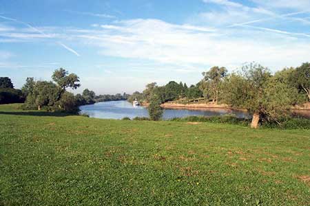
River Severn & Apperley from Tewkesbury
Gloucestershire Walk
County/Area - Gloucestershire
Author - Lou Johnson
Length - 7.5 miles / 12.2 km Ascent - 300 feet / 91 metres
Time - 4 hours 0 minutes Grade - easy/mod
Maps 

| Ordnance Survey Explorer 190 | Sheet Map | 1:25k | BUY |
| Anquet OS Explorer 190 | Digital Map | 1:25k | BUY |
| Ordnance Survey Explorer 179 | Sheet Map | 1:25k | BUY |
| Anquet OS Explorer 179 | Digital Map | 1:25k | BUY |
Walk Route Description
Click image to see photo description.
The River Severn is one of Britain's great rivers and this walk follows its banks south to the village of Apperley before turning in land to cross fields back to the start. The view to the west includes the Malvern Hills which rise along the skyline. The walk also offers the opportunity to explore the town of Tewkesbury which is dominated by its Abbey. Further ecclesiastical interest along the way includes Odda's Chapel which is one of the best preserved Saxon buildings in England.
The start is the car park (grid ref. SO888322) on the west side of Gloucester Road a short way south of the Abbey. After parking exit the car park and turn right (south) along Gloucester Road. In a few metres you will reach a lane on your right. Walk down this lane following the Severn Way long distance path and continue the kilometre or so to reach the River Severn. Bear left along the river and follow the path with the river to your right. You now have just under three miles of easy walking before you turn inland. Along the way you can make a short diversion by leaving the riverside path at grid ref. SO867299 to visit St Mary's Church and Odda's Chapel in Deerhurst. After completing these visits return to the riverside path and continue south to reach the Coalhouse Inn (grid ref. SO854283).
The route now turns inland. Initially follow the access road to the Inn, where the road bends sharp left, follow the footpath ahead. This path leads gently uphill to reach the road at the southern end of Apperley village (grid ref. SO861281). Turn left along the road to the road junction with a grassed island. Turn right here along Sawpit Lane. After 400 metres take the footpath on your left just past Apperley Village Hall (grid ref. SO866285). After just over 100 metres bear right onto a footpath which leads across fields to reach the end of a track just south of Deerhurst Vicarage (grid ref. SO872292). Ignore the track (on your left) and continue ahead. The path soon turns left and continues north to reach a lane (grid ref, SO873297).
Cross the road and take the continuing path as it initially follows the west bank of small stream. At grid ref. SO874303, the path turns left to reach the edge of a wooded slope (Rayer's Hill) before turning right to follow the edge of the wood. Stay on this path using the edge of the wood as your guide and continue north. The path continues alongside a golf course and eventually joins a driveway which leads onto the lane used for the first section of the walk from Tewkesbury. Bear right along the lane and retrace your steps back to the car park used at the start of the walk.
Other walks nearby
| Walk 1853 | Bredon Hill from Kemerton | easy/mod | 5.2 miles |
| Walk 2445 | Upton-upon-Severn Circular | easy/mod | 6.8 miles |
| Walk 1949 | Nottingham Hill | easy/mod | 4.5 miles |
| Walk 2402 | Bredon Hill from Elmley Castle | easy/mod | 5.5 miles |
| Walk 2495 | Bredon Hill Circular | moderate | 10.6 miles |
| Walk 2380 | The Malverns from the Gullet | moderate | 12.0 miles |
| Walk 2326 | Herefordshire Beacon from Hollybush | easy/mod | 6.5 miles |
| Walk 3064 | Hailes, Beckbury & Sudeley from Winchcombe | moderate | 10.0 miles |
| Walk 3065 | Cleeve Common & Belas Knap from Winchcombe | moderate | 10.0 miles |
| Walk 2664 | Herefordshire Beacon from British Camp car park | easy | 2.0 miles |
Recommended Books & eBooks
No suggestions for this area.Messaging & Social Media
Message Walking Britain and follow the latest news.

Mountain Weather
Stay safe on the mountains with detailed weather forecasts - for iOS devices or for Android devices.