Walk 2681 - printer friendly version
Wetton & Manifold Valley from Wetton Walk
Author - Lou Johnson
Length - 3.6 miles / 5.9 km
Ascent - 800 feet / 242 metres
Grade - easy/mod
Start - OS grid reference SK108553
Lat 53.0947990 + Long -1.8401749
Postcode DE6 2AF (approx. location only)
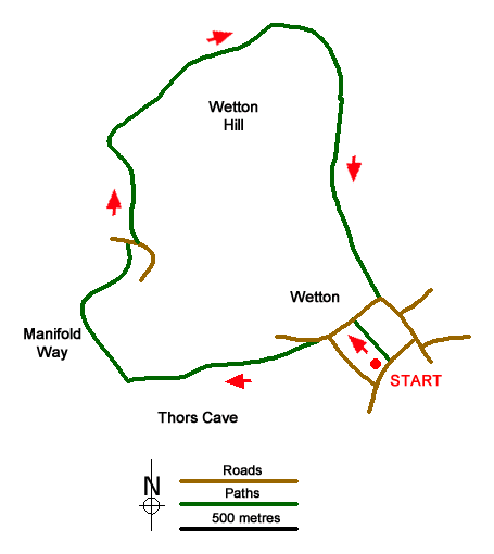
The start of this Peak District walk in the White Peak is the free car park at grid ref. SK108553 where there are public toilets. This car park is signed from most roads entering the village. Cross the stile at the back of the car park (no footpath sign) and cross a large paddock usually with horses grading. Continue across the paddock to a lane. Turn left and follow the lane bearing right at the first junction. On the left there is a signed track to Thor's Cave and immediately after a footpath sign pointing down a field towards the Manifold Valley. Although Thor's Cave is not included in this walk you can include it as an optional 'extra'. Descend the field. At the first footpath junction (Thor's Cave is signed to the left) continue ahead soon reaching a footbridge over the River Manifold.
Cross the footbridge and turn right along the well-maintained Manifold Way. Take care as this is a mixed-use track and you will be sharing the route with cyclists. After about 700 metres of easy walking you reach a lane (grid ref. SK098556). Turn right across the River Manifold (which is usually just a dry river bed) and almost immediately take the footpath on the left. You are now entering the National Trust managed open access area of Wetton Hill. Follow the clear path up the dry valley probably seeing few walkers as make you progress through pleasant limestone scenery.
After about 1.5 kilometres you reach an open area with a three-storey house ahead (grid ref. SK104566). Bear right here on a grassy path climbing steadily with a stone wall to your immediate left. After 500 metres look out for a step stile built into the wall on your left (grid ref. SK107562). Cross this stile and immediately bear right over another stile. The onward path goes half left across this field to another wall stile. Cross this and follow the clear path as it climbs briefly past limestone outcrops. The way ahead is obvious and with good views in all directions you descend to a track with a water reservoir surrounded by grass banks on your left.
Continue down the track into the village of Wetton. Reaching the road (grid ref. SK108554) continue straight ahead. If you wish to visit the café, then turn right here. Walk past the pub (on your right) and continue to the first lane on your right, which has signs directing you to the car park and WC. Turn right and the car park is a short walk along the lane.
Messaging & Social Media
Message Walking Britain and follow the latest news.

Mountain Weather
Stay safe on the mountains with detailed weather forecasts - for iOS devices or for Android devices.