Walk 2701 - printer friendly version
Harboro Rocks & Brassington Walk
Author - Lou Johnson
Length - 6.5 miles / 10.6 km
Ascent - 1150 feet / 348 metres
Grade - easy/mod
Start - OS grid reference SK249528
Lat 53.071859 + Long -1.6298141
Postcode DE4 4DD (approx. location only)
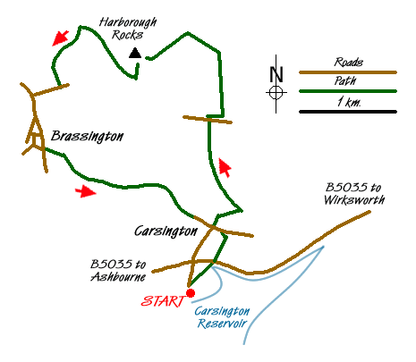
This pleasant walk lies just outside the boundary of the Peak District National Park but still includes some excellent scenery and two picturesque villages. The walk also contains a short section of the High Peak Trail and a rocky summit. The start is the car park overlooking Carsington Water (grid ref. SK249528) on the south side of the B5035 Ashbourne to Wirksworth Road near the village of Carsington. Please note it is not the car park adjacent to the main visitor centre for Carsington Water.
After parking walk towards the entrance of the car park and take either of the footpaths signed on your right. These both lead to the B5035 where care is needed to cross the road and continue along the footpath on the opposite side of the road into Carsington village. The path, muddy at times, leads into a track. Follow this as it becomes a lane and leads to the crossroads in the village centre (grid ref. SK251534). From this road junction take the signed footpath between houses that heads north. After a short enclosed section the path enters a large field and climbs steeply uphill. Do be careful as there are many former mine shafts on the next section of the walk so keeping to the path is the recommended option.
The path reaches the boundary of a wood. Do not continue into the wood, instead go half left and with the stone wall on your right continue past the Kings Chair to a road (grid ref. SK250546). Turn right along the road for a short way. On your left is a gate leading onto the High Peak Trail as it goes east towards Middleton Top. The High Peak Trail follows the former track bed of the Cromford & High Peak Railway. If you need a short break, then approximately 200 metres down the trail is a former railway cottage with some picnic benches beside the trail. This makes a pleasant stop and also allows you to view the impressive incline just to the east of the station.
Between the road and the former station, turn left on a signed footpath (grid ref. SK252546). This leads across fields to a wide track. Turn left on this track and continue to a footpath junction (grid ref SK248556). Turn left here alongside a wall towards New Harboro Farm. The path goes to the right here before starting to climb onto Harboro Rocks. A short diversion off the path to the trig point on the summit is a worthwhile diversion. The path descends to reach the High Peak Trail. Turn right.
After about a kilometre (grid ref SK236556), take the footpath on the left - the Limestone Trail. This leads uphill and then descends past a small farm to reach Manystones Lane (grid ref. SK234550). Turn right along this lane, left at the first junction and start the descent into Brassington village. It is more pleasant to go right at the first fork following a minor lane into the village. There is a pub and a convenient bench in the churchyard also makes a perfect place for a break.
To continue, descend down the lane keeping the pub on your right to reach the main road through the village. Reaching this main road, the onward footpath is opposite reached via a farm yard almost straight ahead. The path then crosses a couple of pastures before climbing steeply over grass to reach a wall (grid ref. SK234542). Cross the wall and turn right. The path is obvious as it contours across the hillside. Reaching a gravel lane go straight across climbing slightly before starting the final descent into Carsington village. The route is never in doubt and you soon reach a gate leading into a tarmac lane (grid ref. SK248535). Continue along the lane past cottages into the centre of the village where you retrace your steps back to the car.
Messaging & Social Media
Message Walking Britain and follow the latest news.

Mountain Weather
Stay safe on the mountains with detailed weather forecasts - for iOS devices or for Android devices.