Scout Scar Limestone Ridge
Lake District Walk
Nat Park - Lake District - Lake District Lesser Fells
County/Area - Cumbria
Author - Dave Melling
Length - 5.0 miles / 8.1 km Ascent - 820 feet / 248 metres
Time - 3 hours 20 minutes Grade - easy/mod
Maps 

| Ordnance Survey Explorer OL7 | Sheet Map | 1:25k | BUY |
| Anquet OS Explorer OL7 | Digital Map | 1:25k | BUY |
| Ordnance Survey Landranger 90 | Sheet Map | 1:50k | BUY |
| Anquet OS Landranger 90 | Digital Map | 1:50k | BUY |
Walk Route Description
Click image to visit gallery of 2 images.
Situated on the edge of the Lake District National Park, Scout Scar offers an incredible 360degree panorama view of Lancashire, Yorkshire and Cumbria. Trees bent by the wind, rare orchids and a dazzling array of butterflies add to the attractions. This is an excellent start or finish to a holiday as it only takes half a day, leaving plenty if time to reach your final destination.
The start of this Lake District walk can be a little difficult to find. The best approach is from Levens village and onto Brigsteer and then up the side of Scout Scar on the Brigsteer road, parking down the track at Helsington Church (grid ref. SD489889). Walk northwards back along the track to the Brigsteer road. Go right up the road and through the kissing gate on the left. Follow the obvious grassy track along the edge of Helsington Barrows.
Scout Scar and Helsington Barrows form a ridge which has a lot of limestone scree rather than the more familiar limestone pavements found further in east in the Yorkshire Dales. This is excellent habitat for a wide range of flowers including the unusual fragrant, fly and early purple orchids. The flowers of course attract butterflies such as the pearl bordered fritillary, northern argus and the wonderfully named thyme pug moth.
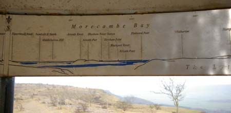
Pass through the stone wall going onwards to another wall where the track bears right alongside the wall. At the end of the wall cross the ditch and follow the path up to the gap at the top of the scar. Follow any of the paths heading generally northwards along the scar. Keep going north until the mushroom shaped shelter is eventually reached. Although modern looking the shelter was actually built in 1912 as a memorial to King George VI . A close inspection inside reveals a 360 degree annotated panorama on the rim of the dome. The views across are staggering and include Blackpool Tower, the Old Man of Coniston, the Langdales, the Howgill Fells and the Yorkshire Dales. Quite impressive for a hill with a height of only 230metres.
Having taken in the view head back southwards keeping to the edge of the scar looking for dip and a cairn above Barrowfield Farm. Follow the track that heads down the scar and through the trees to the farm. Follow the signs round the left hand side of the farm, turning left along the track go onto the path at the signpost through Honeybee Wood. As a mixed limestone wood this habitat provides a complete contrast to Scout Scar.
At the Brigsteer road go right downhill a short distance and onto the narrow lane on the left heading for Wells Garth. At the junction take the track up the hill. Continue upwards past the house and go through the gate into the field, following the well worn track After about 200 metres go up the field in a northerly westerly direction to return to Helsington Church. A short visit to the church reveals an unusual worked leather frontage to the altar with an early 20th century mural above it.
Other walks nearby
| Walk 1148 | Scout Scar from Sizergh | moderate | 11.0 miles |
| Walk 2143 | Whitbarrow & Lord's Seat | easy/mod | 5.4 miles |
| Walk 1045 | Levens Bridge to Kendal | easy/mod | 11.5 miles |
| Walk 3451 | Underbarrow, Lord's Lot and Crossthwaite | easy/mod | 5.6 miles |
| Walk 3199 | Whitbarrow Fell from Mill Side | moderate | 7.0 miles |
| Walk 3549 | Whitbarrow Scar from Mill Side | moderate | 6.5 miles |
| Walk 3452 | Ghyll Head & Strawberry Bank Circular | moderate | 7.6 miles |
| Walk 1555 | Brunt Knott from Staveley | easy/mod | 7.0 miles |
| Walk 1049 | Staveley Tarns circular | easy/mod | 6.0 miles |
| Walk 2464 | Kentmere Valley Circular | moderate | 10.0 miles |
Recommended Books & eBooks
Lake District: Low Level and Lake Walks
 This guidebook describes 30 of the best low-level walks in the Lake District. From delightful wooded glades and sparkling tarns, to waterfalls and glacier-carved valleys towered over by craggy mountains. The walks described aim to seek out the best walking that the lower areas of the Lake District have to offer.
More information
The Cumbria Way
 A guidebook to the 73 mile Cumbria Way, an easy long-distance walk though the heart of the Lake District National Park, from Ulverston in the south to Carlisle in the north, with good transport links to either end. The route is largely low-level but this guide offers alternative mountain days to climb some of the famous fells en route.
More information
Messaging & Social Media
Message Walking Britain and follow the latest news.

Mountain Weather
Stay safe on the mountains with detailed weather forecasts - for iOS devices or for Android devices.