Walk 2722 - printer friendly version
Covenham St. Bartholomew & the Reservoir Walk
Author - Hugh Marrows
Length - 4.8 miles / 7.7 km
Ascent - 20 feet / 6 metres
Grade - easy
Start - OS grid reference TF337945
Lat 53.430342 + Long 0.01089971
Postcode LN11 0PF (approx. location only)
This walk explores Covenham village with its nearby reservoir. Both the Covenhams (St. Mary's and St. Bartholomew's) have a church and the two villages blend imperceptibly. The boundary is near St Bartholomew's church where a village name sign shows both; one on either side. Their names come from the Old English "Cofa's Ham" (i.e. homestead) and were separate villages in the mid 1400's, being known then as Covenham Sancti Bartholomei and Covenham Sancti Marie. However we see St Bartholomew only on our walk.
St. Bartholomew's church is an pleasing mixture of chalk and greenstone repaired with red brick and has some C13th stonework that survived its substantial restoration in 1854. It has been redundant since 1981 and will probably be locked though the inside can be seen through the windows. Look too for the impressive (but weather-beaten) carved head over the porch door. The churchyard is now a nature reserve known affectionately as "God's Acre".
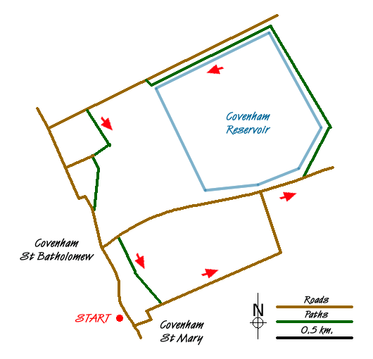
Covenham Reservoir by contrast is an enormous man-made landscape feature and managed by Anglian Water to cater for C20th demands both for water and leisure facilities. Its construction took two years and once completed in 1969 it took another year to fill by drawing water from the Great Eau and the Louth Navigation. Further statistics only serve to emphasise its size. The surface area of the water is 218 acres, the depth reaches 15 metres and the circumference measures almost two miles. One corner is designated as a nature reserve and because of this there is public access to a perimeter path that allows observation of the many birds that use it, especially during the winter. It leisure uses include a sailing club, wind surfing and water skiing.
In the large meadow crossed near Manor Farm on the return to Covenham St Bartholomew's the obvious earthworks form part of the original village site and prehistoric flints have been found in the fields between Grange Lane and Birketts Lane indicating an even earlier history of occupation.
When you return to the inn look for the huge terra cotta plaque on the end wall bearing the date 1898.
Notes There is alternative parking at the northwest corner of the reservoir (GR340964) and starting there puts the inn half way round the walk.
Route Guide.
Leave the inn carpark and turn right for a few yards to St. Bartholomew's church and then bear left down Birkett's Lane. After about three-quarters of a mile when the road ends keep forward along a grassy track that soon bears left to meet another road.
Turn right for 25 yards, then go over a stile on the left and climb the steps onto the reservoir embankment to join the perimeter footpath. (The public may use this although it is not a right of way.)
You can walk round in either direction. If you go left (which saves half a mile), pass in front of the Boat Club building to reach steps just around the next corner and descend to the road. I recommend turning right however to walk round three sides of the reservoir where the high vantage point provides wonderful views eastwards over the marsh and inland towards the Wolds. At the corner before the Boat Club descend steps on the right to the road.
Turn left for 500 yards (taking care with children or pets) to a footpath sign and footbridge on your left. From it cross an arable field aiming just left of a bungalow on the far side. Once across keep forward to the left of a line of trees and at the end turn right to join a lane, where in about 50 yards a footpath sign points left into a house drive. Where the shrubs on the right end veer right over the garden to a waymark at a footbridge. Now bear half right cutting a field corner (or use the field edge) to a ladder stile and from it turn half left over a large meadow, taking a diagonal line to the fields far corner. Head between Manor Farm and a house and you'll come to a second ladder stile. Join a road and turn left.
At the junction with Grange Lane keep ahead to the inn - but my choice would be to turn left for 100 yards and then take the signed footpath from a stile on the right. At first the path is between a fence and hedge but after a second stile turn left to continue in a meadow, now with the hedge on your left. Cross the footbridge in the field corner into a third field. Now aim slightly left to a hedge gap on the opposite side where there is another stile. In the final field head towards the right hand one of two large trees to a final stile and a lane.
This is Birkett's Lane again; turn right back to the village and inn.
Messaging & Social Media
Message Walking Britain and follow the latest news.

Mountain Weather
Stay safe on the mountains with detailed weather forecasts - for iOS devices or for Android devices.