Chesterfield Canal and Anston Brook from Kiveton
South Yorkshire Walk
County/Area - South Yorkshire & Nottinghamshire - Doncaster Rotherham
Author - Andy Chaplin
Length - 10.2 miles / 16.6 km Ascent - 450 feet / 136 metres
Time - 5 hours 30 minutes Grade - moderate
Maps 

| Ordnance Survey Explorer 279 | Sheet Map | 1:25k | BUY |
| Anquet OS Explorer 279 | Digital Map | 1:25k | BUY |
Walk Route Description
Click image to visit gallery of 3 images.
This 10-mile walk takes in four and a half miles of the Chesterfield canal to Shireoaks, a mile through Lindrick golf course and one and a half miles along the Anston Brook in Anston Stones Wood. These sections are particularly pleasant bits of countryside. The downside is having to cross the A57 twice.
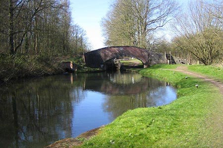
The walk starts at the Canal and River Trust car park just south of Kiveton Park (grid ref. SK494825). Cross the road and then take the path that follows the route of the old canal on the Cuckoo Way. The first sign you see tells you it is over 32 miles to the river Trent. The canal proper starts just after the partially collapsed Norwood tunnel. Continue along the canal path for four miles. It is a particularly pretty route and notice boards about the shipment of stone for the Houses of Parliament and the flights of locks make it historically interesting.
At Shireoaks take Shireoaks Common road past the station and after 400 metres turn off left down Brancliffe Lane past St Luke's C of E School. A path on the right follows the edge of the fields towards Deep Carrs Farm and the A57. Crossing the road can be difficult, but with luck traffic will be slowing for the next roundabout so you may get let across by the queuing motorists.
Follow the path on the opposite side of the road through the golf course toward the houses on Lindrick Road. When you have crossed a couple of fairways follow the road to the left all the way past Lindrick House. It carries on as a track then as a path through the woods on the way back to the A57. Assuming it is still there post 2017 - you will pass what seems to be a ground-to-air missile in someone's front garden - which should deter low-flying burglars.
Walk westwards on the A57 pavement for 250m then take the path off on the right into Anston Stones Wood. The path follows the Anston Beck heading down to the railway bridge. There is an information board here giving some details of the Duke of Leeds, who owned the woodlands, and the paths through the wood. Passing under the railway for the first time, keep the railway on the right and the brook on the left.
To stay on the right of the brook you need to go under the railway at grid ref. SK526835 and then continue along until you come to the Ryton Road. Turn left under the railway bridge then off right on the footpath that dog-legs back to the A57. Cross the main road and take the path to West Street. You pass a small garden/graveyard on the right that has more of the Houses of Parliament stonework in one of the corners.
Turn right onto Axle Lane then take the path on the right across the fields to Kiveton Hall Farm. One of the buildings here notes that it was built by an ex-POW August Schleusener in 1955. When you come out on the main road take Kiveton Lane then Hard Lane southwards back to the car park.
Other walks nearby
| Walk 1937 | Morthen & Upper Whiston from Ulley | easy/mod | 8.8 miles |
| Walk 1836 | The Moss Valley from Ford | moderate | 9.3 miles |
| Walk 2139 | Clumber Park and Lake | easy | 4.0 miles |
| Walk 2162 | Clumber Park & Freeboard Lane | easy | 5.5 miles |
| Walk 2456 | Flask Edge from Dronfield Woodhouse | moderate | 10.0 miles |
| Walk 3440 | Sheffield Round | moderate | 15.2 miles |
| Walk 3330 | Rivelin Valley from Malin Bridge | easy/mod | 9.7 miles |
| Walk 3436 | Hillsborough to Bradfield & Loxley Valley | moderate | 12.6 miles |
| Walk 1460 | Hardwick Hall park | easy | 2.5 miles |
| Walk 2728 | Wadsley and Loxley Commons, Sheffield | easy/mod | 7.9 miles |
Recommended Books & eBooks
No suggestions for this area.Messaging & Social Media
Message Walking Britain and follow the latest news.

Mountain Weather
Stay safe on the mountains with detailed weather forecasts - for iOS devices or for Android devices.