Walk 2732 - printer friendly version
Darwen Tower & West Pennine Moors Walk
Author - Lou Johnson
Length - 5.5 miles / 8.9 km
Ascent - 900 feet / 273 metres
Grade - easy/mod
Start - OS grid reference SD665215
Lat 53.688868 + Long -2.5087523
Postcode BB3 0PA (approx. location only)
The West Pennine Moors lie to the west of Darwen and offer some excellent walking. Rising to 400 metres above sea level the moors are well known for the prominent landmark of the Darwen or Jubilee Tower which was constructed to celebrate Queen Victoria's Diamond Jubilee in 1897. The walk starts from the car park by the Royal Arms Hotel and café (grid ref. SD665215) where there are public toilets and information available. This area has many paths and tracks and it is recommended that you take the relevant OS 1:25000 map to help with navigation.
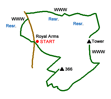
After parking cross the road and take the bridleway through gate. The track descends north-west through woodland towards the Upper Roddlesworth Reservoir. Reaching a junction, bear right following the sign to 'woods and water trail'. When a path joins from the right descend to the left down steps. Continue through a gap in the fence and go right a path junction. Continue and descend over a stream ascending to go half right at a fork where the path curves to the left. Climb through woodland bearing left to reach a gate and a road. Walk left along the road for about 150 metres and cross road to follow track (grid ref. SD662222).
Continue along this track for 500 metres to a junction of paths (grid ref. SD667223). Go straight over descending to cross the dam wall of Earrsdale Reservoir. Follow the lane as it bends right and then left to pass between trees to reach a junction with a building on the left (grid ref. SD676222). Take the rising lane heading south-east. Where this lane bends to the right, continue ahead on a path across a field to a wider track (grid ref. SD680222).
Turn right up this track. After 100 metres or so, keep straight ahead ignoring the path veering right. Stay on the 'main' track and continue to the Darwen Tower with its adjacent trig point (grid ref. SD678215). From the south side of the Tower take the clear path heading south. You are now following a section of the Witton Weavers Way. After 600 metres from the Tower you reach a junction (grid ref. SD680209). Bear left here and continue for 150 metres to a path 'crossroads' (grid ref. SD681209).
Turn left and follow this path for a kilometre passing a path coming in from the right and one from the left. Reaching the next junction (grid ref. SD674204) just before a clump of trees, bear right and continue on the clear track as it curves left then right and sharp left again. 140 metres after the sharp left bend (grid ref SD668203) take the grassy path on the right. This path initially heads north and then swings northeast leading to the spot height 366. The short climb is worth the extra effort as the summit offers a fine view to the north.
Retrace your steps downhill, bearing right at the first path junction and continue walking to reach New Barn Farm (grid ref. SD668208). Turn right in front of farm and follow grassy path along the wall, which is to your left. Continue along the wall to the corner of a small wood and a clear track. Turn left along the track back to the start.

Mountain Weather
Stay safe on the mountains with detailed weather forecasts - for iOS devices or for Android devices.

