High Vinnals & Richard's Castle
Herefordshire Walk
County/Area - Herefordshire & Shropshire
Author - Lou Johnson
Length - 6.0 miles / 9.8 km Ascent - 1000 feet / 303 metres
Time - 4 hours 0 minutes Grade - easy/mod
Maps 

| Ordnance Survey Explorer 203 | Sheet Map | 1:25k | BUY |
| Anquet OS Explorer 203 | Digital Map | 1:25k | BUY |
Walk Route Description
Click image to see photo description.
This walk on the border of Herefordshire and Shropshire offers far reaching views across three counties and towards the Brecon Beacons. The route uses sections of the Mortimer Trail and the Herefordshire Trail and provides the opportunity to visit St Bartholomew's church and the ruins of the Castle in the village of Richard's Castle. The start is the free car park at Black Pool on the west side of the B4361 near the Shropshire village of Overton at grid ref. SO497717.
From the overflow car park near a sharp bend in the access track follow the Blackpool Loop path. The path climbs through the trees. At the first junction, bear right and then left where the path divides following the signs to the Mortimer Trail. Having gained the Mortimer Trail, walk west climbing steadily. Initially the Trail passes through plantations but soon reaches open country with improving views.
250 metres after leaving the forested area the path divides. Bear right staying on the Mortimer Trail. Continue straight ahead at the next junction (grid ref. SO479726) where a track comes in from the left and ignore the track going off to the right. The Mortimer Trail then curves south to reach the summit of High Vinnals where you need to allow time to enjoy the expansive views.
Descend south off the summit to reach a junction of tracks where the Herefordshire Trail comes in from the right (grid ref. SO477715). Pick up the grass path through woodland to a gate and into field. Continue across the field with the field boundary on your right. Cross the access drive to Vallets Farm with field boundary still on your right. Continue to the south-western corner of this field. Go through the gate beside a small enclosure. You are now faced with three gates. Take the left-hand gate to join an enclosed track between hedges.
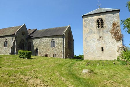
Continue down the enclosed track for about 200 metres to a gate on your left. Go through this gate signed as the Herefordshire Trail (grid ref. SO472700). Keep the hedge on your left and cross field to a gate to join a track which descends into a valley. Stay on the Herefordshire Way to reach Richard's Castle (grid ref. SO485702). Allow time to visit the church and the remains of the castle.
After visiting the church and castle, continue to the lane through the village and turn right downhill (southwest). Follow Wheatcommon Lane to a crossroads with a half timbered cottage on the right (grid ref. SO488700). Turn left, signed Ludlow, and follow this lane passing a footpath on the right to reach a stile and footpath sign on the left after 400 metres (grid ref. SO490703). Initially go half right and then bear left up the field to a metal gate and a lane (grid ref. SO489706). Turn right and after 120 metres take the footpath on the left through a metal kissing gate.
The path continues with a hedge on your left descending gently to join a bridleway. Continue straight ahead along the bridleway to a lane (grid ref. SO491709). Go straight across onto a footpath and walk through trees soon joining a track by some houses. Continue ahead onto a grassy path which passes through trees. This path soon reaches Black Pool (grid ref. SO497716) and the B4361. Turn left along the road and you are soon back at Black Pool car park and the end of the walk.
Other walks nearby
| Walk 3221 | High Vinnalls, Burrington, & Richard's Castle | mod/hard | 11.0 miles |
| Walk 2654 | Titterstone Clee Hill & Cleeton St. Mary from Cleehill | moderate | 7.5 miles |
| Walk 3442 | Haws Hill from Tenbury Wells | easy/mod | 6.6 miles |
| Walk 3334 | Titterstone Clee Hill and Catherton Common | easy/mod | 5.5 miles |
| Walk 1203 | Stokesay Castle & View Edge | moderate | 8.0 miles |
| Walk 3014 | Leominster Circular | easy | 5.0 miles |
| Walk 1673 | Shobdon Hill and Croft Ambrey from Shobdon Estate | moderate | 12.5 miles |
| Walk 1998 | Harley's Mountain from Lingen | easy/mod | 7.5 miles |
| Walk 2022 | Wenlock Edge & Aston Munslow | moderate | 7.8 miles |
| Walk 2633 | Brown Clee Hill | easy/mod | 6.3 miles |
Recommended Books & eBooks
No suggestions for this area.Messaging & Social Media
Message Walking Britain and follow the latest news.

Mountain Weather
Stay safe on the mountains with detailed weather forecasts - for iOS devices or for Android devices.