Walk 2842 - printer friendly version
Sandon Park from Salt Walk
Author - Lou Johnson
Length - 4.6 miles / 7.5 km
Ascent - 350 feet / 106 metres
Grade - easy
Start - OS grid reference SJ958278
Lat 52.847686 + Long -2.0638053
Postcode ST18 0BT (approx. location only)
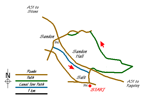
This short walk includes a section of the Trent valley and the pleasant parkland of Sandon Hall. The start is the village of Salt (Grid ref. SJ 958278) which can be reached from the A51 Stone to Rugeley road by turning off either at Sandon or Weston. Parking on the road through the village is possible although do take care not to block residents' access.
After parking, take the tarmac lane opposite the Hollybush Inn and walk north, crossing the canal and railway, to reach the A51. Cross this busy dual carriageway and go through the gate opposite into the grounds of Sandon Hall. Follow the track for a short way to reach a signed footpath leading to your right. Follow this path up a field to stile and a track (grid ref. SJ962281). Turn right along the track into woodland. Keep to the left at the first fork and at the second fork, keep to the right (the lesser used track) and follow this through the woods. This track soon bends to the right and drops down to meet another track with a gate opposite.
Follow the signed path beside this gate to join a field track. Follow this track over two small streams. Continue ahead maintaining an easterly direction to pass by a small area of woodland on your right (grid ref. SJ969281). At the end of this field, you cross the next field aiming half left. Locate the stile, tucked away in a corner, at the far end of this field. Cross the next field half left and continue over another stile to reach a small footbridge (grid ref. SJ974284).
Don't cross the bridge. Instead turn left into the corner of the field to cross a stile. The path then follows a hedge (on your right) to reach a small pond on your right. Continue across the next field. In the next field aim to the left of the small area of woodland and locate a stile and footbridge in the hedge. Bear half right and pick up a field track that soon goes through a gap in a hedge to continue alongside a hedge to reach a stile (grid ref. SJ965286). Cross the stile and follow the waymark across a well surfaced track climbing steadily up the grassy hillside beyond the track.
As you gain height bear slightly right until you have reached the crest of the hill. Then bear right following the crest of the hill up towards a stone pavilion which should be about 100 metres away on your right. Maintain direction keeping the small wood (High Clump) to your right. You will soon reach a stile in the hedge (grid ref. SJ959295).
Turn left down this lane and follow it past the moated farm on your left to reach Sandon Church. Enter the churchyard and take the path leading down through the graveyard to a gate in the western boundary fence. Follow the path across a field to reach a lane (Grid ref. SJ 951294). Go left down the lane to reach the A51. Cross with care and walk along the road opposite with the pub on your left. Cross the railway and continue along the lane to reach a bridge over the Trent & Mersey canal. Turn right just over the bridge to gain access to the towpath. Go right under the bridge and follow the canal for about a mile as far as the first bridge (Grid ref. SJ 958281). Walk up to the road and turn right along the lane into the village of Salt.
Messaging & Social Media
Message Walking Britain and follow the latest news.

Mountain Weather
Stay safe on the mountains with detailed weather forecasts - for iOS devices or for Android devices.