Gallt yr Ogof & Braich y Ddeugwm
Snowdonia/Eryri Walk
Nat Park - Snowdonia - Glyders Tryfan
County/Area - Conwy
Author - Jake Robertson
Length - 4.0 miles / 6.5 km Ascent - 1900 feet / 576 metres
Time - 3 hours 50 minutes Grade - moderate
Maps 

| Ordnance Survey Explorer OL17 | Sheet Map | 1:25k | BUY |
| Anquet OS Explorer OL17 | Digital Map | 1:25k | BUY |
| Ordnance Survey Landranger 115 | Sheet Map | 1:50k | BUY |
| Anquet OS Landranger 115 | Digital Map | 1:50k | BUY |
Walk Route Description
Click image to visit gallery of 4 images.
I did this Snowdonia (Eryri) walk with a friend whilst camping at Gwern Gof Isaf and in need of an easy half day we decided to have a look at the two mountains above the campsite, Gallt yr Ogof and Y Foel Goch. To our pleasant surprise they turned out to be a grand pair, far more than merely "the eastern tops", Gallt yr Ogof especially, but perhaps the best part of the route was the descent down the neglected Braich y Ddeugwm ridge - the mountain views are simply magnificent. All in all, it is a worthwhile easier half day in quiet terrain.
The start is the car park at Gwern Gof Isaf farm where you pay for parking at the farmhouse. Follow the main track through the campsite going left soon crossing the Nant yr Ogof and passing through a gate into more open country. Walk a few yards along the track then leave its comforts by crossing a newly constructed drain and beginning the slow ascent of Gallt yr Ogof. Head directly up the immediate slopes picking your way around bogs and boulders, veering left slightly until you meet a barbed wire fence running across the hillside. Cross it at the first stile you come to and follow it up onto the ridge, though the actual crest is a lot further than appears being hidden by a low line of rocks!
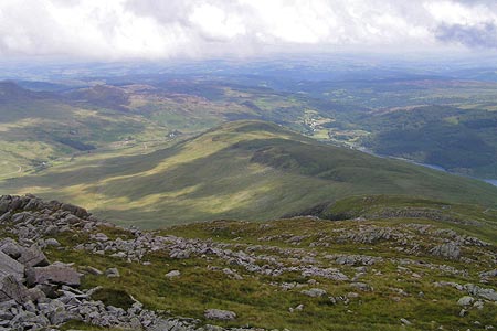
The views down to Capel Curig upon gaining the ridge are a nice reward for the effort and it is now a fairly easy walk up the ridge with occasional easy scrambling to the summit cairn at 763m/2503ft which appears after a false summit (groan!). This is a superb and airy viewpoint, looking directly down to Betws y Coed, the Clywdians, Berwyns and the nearby higher summits of Eryri. Moel Siabod looks particularly massive over the Nant Gwryd and despite being surrounded by higher peaks there is a lovely sense of content up here, nobody to disturb the peace with most of the crowds on Tryfan - a lovely mountain but a far inferior viewpoint to this. On breezy days with the cloud clipping any summit it fancies one could idle here for hours.
Y Foel Goch is the next summit, reached by a descent to a damp col with a beautiful little llyn followed by a quick climb to the flat top. A cairn on the edge overlooking Gwern Gof Isaf, some 1600ft below marks the highest point at 805m/2642ft. Descend down to the wet marsh to Llyn Caseg-Fraith, take that picture of Tryfan and then forsake any path and go north to the little knoll of Drws Nodded (SH 672585) to locate the top of the Braich y Ddeugwm ridge. If the weather is fine and energy high it may seem silly to descend so soon and in which case Tryfan would be the logical mountain to climb, thus completing a tidy circuit. However; that would be to miss half the point of the walk as the ridge should not be missed and therefore Glyder Fach is a far better summit to climb, albeit on an out-and-back trip that would defeat the idea of having an easy afternoon, but still a highly worthwhile climb at that.
Continuing with the main route, whether you climb Glyder Fach or not, from Drws Nodded the ridge is fairly clear and it is an easy and steady descent with a few scrambles in places. Ignore the path running down the right hand side, it's very wet and misses a lot of the views which make this ridge so good, keep to the crest instead and follow it all the way back down to Gwern Gof Isaf. The ridge breaks a few times but the main crest is pretty obvious to follow and at the end of the ridge go over a ladder stile and down some steps to the farmhouse, the car being a short walk down the track to the road. Braich y Ddeugwm is little used but it offers some of the most magnificent views of Tryfan, Glyder Fach and the Carneddau around, gradually changing perspectives and increasing in grandeur as height is slowly lost, the sun drawing long shadows over Llyn Ogwen and Pen yr Ole Wen late in the afternoon.
Other walks nearby
| Walk 3056 | Pen yr Helgi Du from Ogwen Valley | moderate | 5.5 miles |
| Walk 1150 | The High Carneddau | hard | 10.0 miles |
| Walk 1215 | Tryfan & Llyn Ogwen from Ogwen Valley | mod/hard | 5.5 miles |
| Walk 3001 | Tryfan North Ridge from Ogwen Valley | hard | 3.5 miles |
| Walk 3026 | Tryfan & the Eastern Tops from Ogwen Valley | hard | 5.8 miles |
| Walk 2820 | Carneddau traverse from Llyn Ogwen | mod/hard | 14.0 miles |
| Walk 2650 | Tryfan, the Glyders & Y Garn | very hard | 8.0 miles |
| Walk 1088 | Glyder Ridge traverse | hard | 5.5 miles |
| Walk 1186 | Y Garn | mod/hard | 4.5 miles |
| Walk 3019 | Y Garn & Carnedd y Filiast Ogwen Cottage | hard | 8.5 miles |
Recommended Books & eBooks
Mountain Walking in Snowdonia
 Guidebook to 40 of Snowdonia's best day walks, with routes up Snowdon and Tryfan, including the Snowdon Horseshoe, Cadair Idris, Y Garn and The Rhinogs. The routes range from Grade 1 scrambles like Crib Goch or Bristly Ridge, to riverside and forest walks. Includes details of a 2-day traverse of all 15 of Snowdonia's 3000ft peaks.
More information
Snowdonia: 30 Low-level and easy walks - South
 Guidebook describing 30 walks in Snowdonia, Wales. Routes are mostly low level and on clear paths and showcase the region's beautiful scenery and rich history and culture. Part of a 2-volume set, this southern volume includes Trawsfynydd, Bala, Dolgellau, Machynlleth, the Harlech Coast and the valleys of the Mawddach and Dyfi.
More information
Messaging & Social Media
Message Walking Britain and follow the latest news.

Mountain Weather
Stay safe on the mountains with detailed weather forecasts - for iOS devices or for Android devices.