Walk 2861 - printer friendly version
Pinhaw Beacon from Lothersdale Walk
Author - Allan Friswell
Length - 4.0 miles / 6.5 km
Ascent - 800 feet / 242 metres
Grade - easy
Start - OS grid reference SD958459
Lat 53.909238 + Long -2.0654186
Postcode BD20 8ES (approx. location only)
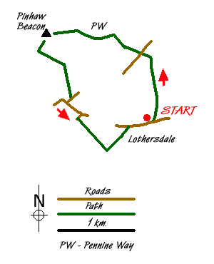
A straightforward ramble, generally well signed with superb views from Pinhaw Beacon. The start point is the Hare and Hounds Public House in Lothersdale (Grid ref. SD958459). Turn left from the pub and then left again almost at once and climb the path signed Pennine Way. After passing through a gate, turn left and follow the fence on your left uphill. The fence becomes a wall about halfway up. Cross the stile in the corner of the field and cross the next field to the stile ahead, which gives on to a lane (Grid ref. SD957469).
Follow the path ahead towards the farm, and where it turns left you should cross the stile and keep straight on along the gravelled track with the wall on your left. The stile in the top corner leads you on to Carleton Moor, ablaze with purple heather when the author did this ramble. Follow the very clear path which soon turns sharp left (Grid ref. SD955472) following close to the wall, and continue all the way up to the trig point of Pinhaw Beacon. The view is truly 360 degrees with the hills of Pendle, Whernside, Pen-y-Ghent, Ingleborough and Buckden Pike all visible. To have attained such a vista after such a straightforward short climb seems hardly fair!
The Pennine Way is clear on the ground and you follow this in a SW direction till you reach the corner of a wall where, ignoring the signposts, you turn left and follow the right hand wall. You quickly come to a waymarker post without its sign (Grid ref. SD942469); here you strike across the moor at veering slightly left, passing a small white pole some kind soul has stuck there for our guidance. When you reach a small plantation (Grid ref. SD943468) you cross the two stiles and turn left along the track to a third stile. In the next field you cross veering slightly right from the stile, making for a wall-stile near the far corner. Cross this and go straight down the field to the stile at the lane by the farm (Grid ref. SD946465). Negotiate the stile opposite and make your way down hill to White Hill Lane. (Grid ref. SD947463).
Here you turn right, then left at the junction, signed "Crosshills, Lothersdale". Walk down the road to the hamlet of The Fold, and turn right in the direction of the fisheries. After some 100 yards take the path on the left. Ignore the fact that it is pointing straight at a wall and follow the clear track down to the bridge across Lothersdale Beck, after passing through a gate. Take the left hand gate after the bridge and climb the path. Where it turns right you should keep to the left and follow the wall, climbing to the stile in the top corner close to Spen House Farm (Grid ref. SD952455). From here, follow the stream to Lower Spen Farm. Pass through the farmyard to the lane - try to ignore the irritating yapping Jack Russell. Then you turn right and follow the road back to the start point.
Messaging & Social Media
Message Walking Britain and follow the latest news.

Mountain Weather
Stay safe on the mountains with detailed weather forecasts - for iOS devices or for Android devices.