Nick of Pendle from Pendleton
Forest of Bowland Walk
Region - Forest of Bowland
County/Area - Lancashire
Author - Lou Johnson
Length - 6.3 miles / 10.2 km Ascent - 920 feet / 279 metres
Time - 4 hours 0 minutes Grade - easy/mod
Maps 

| Ordnance Survey Explorer OL41 | Sheet Map | 1:25k | BUY |
| Anquet OS Explorer OL41 | Digital Map | 1:25k | BUY |
Walk Route Description
Click image to see photo description.
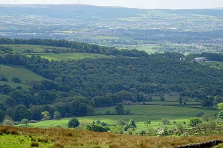
This Forest of Bowland walk starts from the attractive village of Pendleton with Pendleton Brook running through the main street. The route leaves the village and climbs on to the ridge of hills and moorland lying to the southeast of the village from where there are wide views across the surrounding countryside. The walk continues across Pendleton Moor to the Nick of Pendle where the road south from Clitheroe crosses the ridge. From here a brief exploration of The Rough with a visit to the OS trig point completes the route.
The start is the village car park behind the Swan with Two Necks pub (grid ref. SD755396). Exit the car park and turn left and follow the stream uphill ignoring side streets and tracks off to the right. Continue past the Church (on your right) and leave the village. Continue along this road to a T-junction (grid ref. SD762399) by Pendleton Hall. Cross the road and take the signed bridleway passing Pendleton Hall towards Mearley Hall. Just before reaching a junction of tracks at Mearley, locate the waymark post on right and follow the path uphill towards a barn. Go to the left side of the barn into Open Access country (grid ref. SD771403).
Continue ahead across the flank of Mearley Moor towards Howcroft Barn (grid ref. SD772398). Cross the footbridge over Howcroft Brook and bear left on the path with a wall to your immediate right. When the wall turns sharp right maintain direction following sometimes indistinct paths to reach the Clitheroe Road (grid ref. SD772391). Turn left up the road for 150 metres to the ski slope. Here take the signed footpath climbing up to the ridge. Turn right along the wide ridge path down to the road at the Nick of Pendle.
Walk southeast down the road to take the first bridleway on the right through a metal gate (grid ref. SD772383). Stay on this track passing the farm buildings of Wilkin Heys on your left. 250 metres past these buildings locate a path on the right. After an initial steep section, the gradient eases as the path gains the plateau. If you lose the path maintain a north-westerly direction to reach the OS trig point at 315 metres above sea level. If you have time, a short detour to visit Jeppe's Grave lying to the south west is worthwhile and is reached by a stile and ladder stile.
From the OS trip point walk north east picking up a grassy track with leads in just over a kilometre to the small car park at the Nick of Pendle (grid ref. SD771385). Continue up and over the brow of the road and take the signed footpath on the left (grid ref. SD771385). Follow this path downhill towards Wymondhouses Farm. After 500 metres go through gate on the right and aim for the left-hand end of the farm buildings. Cross the stream, go through a gate and then cross a stile and walk down field with hedge to your right. Then go left over a stile and across a field with the hedge again to your right. Go over a stile, and turn left along the hedge (now on your left). Continue downhill to cross a footbridge. Maintain direction down the field to reach the road in Pendleton. Turn left down the road and the car park is just past the pub on your right.
Other walks nearby
| Walk 2217 | Clitheroe Town Trail - Ribble Valley | easy | 1.0 miles |
| Walk 1818 | Downham & Pendle Hill | moderate | 8.0 miles |
| Walk 1655 | Downham & Pendle Hill (short version) | moderate | 6.3 miles |
| Walk 1267 | Pendle Hill | moderate | 5.0 miles |
| Walk 1287 | Circuit of Pendle Hill | moderate | 8.5 miles |
| Walk 2720 | Pendle Hill (use in mist) | moderate | 5.0 miles |
| Walk 2632 | The Ribble Valley from Sawley | easy/mod | 9.0 miles |
| Walk 3111 | Barley Circular | easy/mod | 7.5 miles |
| Walk 3619 | Ribchester Circular | easy/mod | 7.0 miles |
| Walk 2384 | Hodder Valley from Whitewell | easy/mod | 6.8 miles |
Recommended Books & eBooks
Walking in the Forest of Bowland and Pendle
 A guidebook to 40 diverse circular day walks suitable for walkers with navigational skills. The Forest of Bowland and Pendle are two of north west England's upland AONBs, perfect for walkers who enjoy exploring rough hilly, sometimes pathless terrain. The routes include Ward's Stone, Pendle Hill, Longridge Fell and Fair Snape Fell.
More information
Walking on the West Pennine Moors
 This guidebook describes 30 walks on the West Pennine Moors, around Blackburn, Darwen, Chorley and Bolton, home to some of the most inspiring and exhilarating walking country. The walks range from short, easy rambles to more challenging hikes covering a variety of terrain, all of it easily accessible for day walking.
More information
Messaging & Social Media
Message Walking Britain and follow the latest news.

Mountain Weather
Stay safe on the mountains with detailed weather forecasts - for iOS devices or for Android devices.