Walk 3022 - printer friendly version
Black Hill Walk
Author - Lou Johnson
Length - 9.0 miles / 14.6 km
Ascent - 1650 feet / 500 metres
Grade - moderate
Start - OS grid reference SK072992
Lat 53.489463 + Long -1.8929546
Postcode SK13 1HZ (approx. location only)
The most northerly sector of the Peak District National Park is dominated by Black Hill, which rises to 582 metres above sea level with Holme Moss transmitter mast just over a kilometre east of the summit. Sadly Black Hill has a reputation for being a morass of wet peat and is thus avoided by many walkers. Despite this negative aspect the hill does have many redeeming characters and offers good walking under a big sky. Like many parts of upland Britain route finding is fine in good weather. However the moors around Black Hill see some severe snow storms and are often shrouded in low cloud so good map reading and compass skills are essential.
A variation of this Peak District walk can be found at walk 2621, which includes the wrecks of two Meteor Jets that crashed in 1951 on Sliddens Moss. Like all aircraft wrecks there is a wide scatter of debris and location may take some patience. You are also reminded not to take mementoes home.
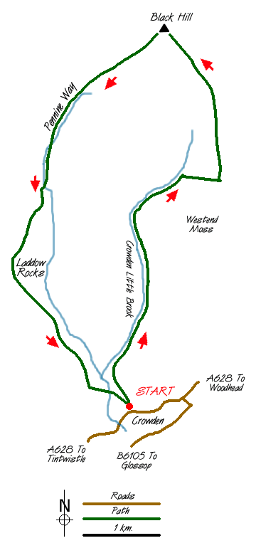
The walk starts from the small carpark (Grid ref. SK 072992) located just north of the A628 at Crowden. Leave the car park by the northern exit and follow the wide track that heads north to the ford marked on the OS 1:25000 map (Grid ref. SK 070998). There is no path on this next section and the route follows Crowden Little Brook upstream. Except after heavy rain it is easy to cross the stream and it is suggested you follow whichever side you find easiest to reach the sheepfolds (Grid ref. SE 075013).
If you prefer to follow paths then an alternative route is to take the footpath from Crowden that climbs east of Brockholes Wood and skirts the quarries that can be seen from the starting point. This path leads to the point above the sheepfolds detailed in the previous paragraph with all walking on clear paths.
From the these sheepfolds turn right scrambling up through the heather for approximately 30 metres to reach a clear path that contours across the side of Hey Moss. Turn left onto the path and head north with Little Crowden Brook down on your left. This section of the valley is a delight with small waterfalls and a feeling of wilderness. Although not marked on maps the path continues to just beyond the sheepfolds (Grid ref. SE 078025).
The next section of route does not follow clear paths and from the sheepfolds follow Whitelow Slack towards White Low (Grid ref. SE 084022) where the main ridge path is met. Turn left on this path and after a short descent to a wide col climb onto Tooleyshaw Moor and head for Black Hill. Recent improvements including paved paths have made the often inaccessible OS trig point on Black Hill much easier to reach! It used to be in the middle of a large area of black liquid peat and finding a dry route was a great challenge!
The summit of Black Hill is too broad to provide great views and is included as a convenient intermediate point on this walk. Leave the summit in a south-westerly direction using the substantial sections of paved path that form the Pennine Way to speed onward progress back to Crowden.
The route is pleasant with Laddow Rocks soon appearing ahead. Just before reaching these dramatic gritstone cliffs you have a choice. The easier but least interesting option is to take the left fork, which leads you along the base of the crags. The best option is to take the right hand fork and follow the upper edge with superb views down into the valley below. With Laddow Rocks behind you the path needs little description as it descends towards Crowden and the end of the walk.
Messaging & Social Media
Message Walking Britain and follow the latest news.

Mountain Weather
Stay safe on the mountains with detailed weather forecasts - for iOS devices or for Android devices.