Sonning Eye & Shiplake circular
Oxfordshire Walk
County/Area - Oxfordshire
Author - Lou Johnson
Length - 5.7 miles / 9.3 km Ascent - 250 feet / 76 metres
Time - 3 hours 10 minutes Grade - easy
Maps 

| Ordnance Survey Explorer 171 | Sheet Map | 1:25k | BUY |
| Anquet OS Explorer 171 | Digital Map | 1:25k | BUY |
| Ordnance Survey Landranger 175 | Sheet Map | 1:50k | BUY |
| Anquet OS Landranger 175 | Digital Map | 1:50k | BUY |
Walk Route Description
Click image to see photo description.
This walk uses a section of the Thames Path before turning away from the river to cross hills offering views across the outward route. The start is The Flowing Spring where parking is possible for those using the pub (grid ref. SU746767). Alternative parking can be found at a layby 200 metres further along the A4155 towards Henley.
After parking, at the exit turn right along a narrow lane. This is Spring Lane which for part of its length has a footpath running parallel to the road. Continue along the lane to reach the B478 (grid ref. SU7487610). Cross over this road with care and take the minor road opposite. Follow this through the outskirts of Sonning Eye. Follow the road as it bends left and then in a few metres take the signed footpath on the right. This leads down to the river and returns to the B478.
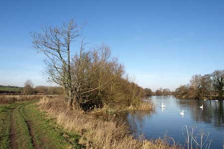
Turn right along the B478 and continue for 200 metres crossing a branch of the Thames. Turn left onto the Thame Path (grid ref. SU754757) crossing a footbridge to reach the west bank of the river. You now follow the Thames Path as it meanders alongside the Thames for about two miles passing the islands of Hallsmead Ait and The Lynch. At grid ref. SU768781, just before Shiplake College, leave the Thames Path and make a 180 degree left turn around a building, going through the school boatyard. Continue to reach the A4155 (grid ref. SU765783). Here bear left and then take the road leading off to the right.
Continue along this road for 300 metres to take the footpath on your left which initially follows the access road to Shiplakecourt Farm. Continue ahead along a track where the access road turns left and follow the path across fields to reach a cross track (grid ref. SU753781). Go straight across on the continuation of the right of way crossing a field to Shiplake Copse. Here the route joins a track which continues to meet a road (grid ref. SU743781).
Turn left along the road passing a church on your left. Where the road bends gently to the right (grid ref. SU743778) take the track and signed footpath on your left. After 250 metres at the junction of tracks (grid ref. SU743776) continue ahead a less distinct track that leads in 800 metres back to the A4155 (grid ref. SU747769). Turn right along this main road and the start of the walk is a short distance away on your left.
Other walks nearby
| Walk 3128 | Henley-on-Thames, Aston and Hambleden | easy/mod | 8.0 miles |
| Walk 3248 | Henley-on-Thames, Rotherfield Greys & Shiplake | easy/mod | 8.3 miles |
| Walk 1919 | Henley-on-Thames, Middle Assendon and Stonor | moderate | 14.5 miles |
| Walk 2051 | River Thames & Hambleden from Henley-on-Thames | easy/mod | 7.0 miles |
| Walk 1720 | Henley-on-Thames to Marlow along the Thames Path | easy/mod | 9.0 miles |
| Walk 1954 | Fingest & Turville from Hambleden | moderate | 11.4 miles |
| Walk 1966 | Turville & Hambleden circular | moderate | 9.6 miles |
| Walk 1982 | Hurley Circular | easy | 5.1 miles |
| Walk 2398 | Turville Circular | easy | 4.1 miles |
| Walk 3420 | Cookham to Gerrards Cross via Burnham Beeches | moderate | 12.5 miles |
Recommended Books & eBooks
The Thames Path Map Booklet
 Map of the 180 mile (288km) Thames Path National Trail, from London's Thames Barrier to the river's source near Cirencester in Gloucestershire. This booklet is included with the Cicerone guidebook to the trail, and shows the full route on OS 1:25,000 maps. The easy riverside route takes around two weeks to walk.
More information
Messaging & Social Media
Message Walking Britain and follow the latest news.

Mountain Weather
Stay safe on the mountains with detailed weather forecasts - for iOS devices or for Android devices.