Five Sisters Ridge, North Glen Shiel
Highland Walk
County/Area - Highland - Central Highland
Author - Paul Gasson
Length - 8.0 miles / 13 km Ascent - 4600 feet / 1394 metres
Time - 8 hours 40 minutes Grade - very hard
Maps 

| Ordnance Survey Explorer 414 | Sheet Map | 1:25k | BUY |
| Anquet OS Explorer 414 | Digital Map | 1:25k | BUY |
| Ordnance Survey Landranger 33 | Sheet Map | 1:50k | BUY |
| Anquet OS Landranger 33 | Digital Map | 1:50k | BUY |
Walk Route Description
Click image to visit gallery of 3 images.
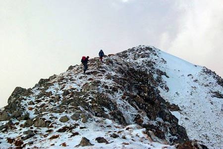
This is undoubtedly one of the classic Scottish hill walks, and no hillwalker who has seen an illustration of it, or viewed it, perhaps from the Mam Rattigan pass out of Shiel Bridge, can have failed to put it on their 'wish list'. It is probably best tackled from it's Eastern end, having taken the precaution of leaving a second car on the road from Shiel Bridge to Morvich (Grid ref. NG947203). Assuming this has been done, return to the A87 and continue down Glen Shiel to a gap between two blocks of forestry on the left of the road (Grid ref. NH007136). Here a pedestrian gate in the deer fence gives access to a clear and well constructed path that makes it way up the 40 degree grassy slope, the longest continuous slope at this angle in Scotland. You have been warned!
The path zig zags up towards the upper level of the forestry on your left, then gives a little respite as it traverses westwards above the forestry, before turning once again to make its way towards the ridge which is gained at about grid ref. NH008145 (the path becomes less distinct as it approaches the ridge as previous hillwalkers have sought the best route through the small rocky outcrops and boulders).
The ridge having been gained, and breathing normalised, turn left and follow the easy slope up to the first of the Sisters, Sgurr nan Spainteach, a Munro top at 990 metres. Here you get the first real view of what lies ahead. Immediately to your left is the deep and steep sided Coire Dhomain, and beyond that, the magnificent spire of Sgurr Fhuaran, the highest point of the ridge at 1068 metres. Beyond Sgurr Fhuaran lies the even deeper valley of Gleann Lichd, and beyond that the great bulk of Beinn Fhada.
The ridge becomes a little narrower as it drops slightly to a small col, before rising easily to the second Sister, the Munro of Sgurr na Ciste Dubh (1027metres). This might be a good spot for some lunch, and to take in the magnificent views all around, notably the South Cluanie Ridge across Glen Shiel, dominated by The Saddle and it's Forcan Ridge almost immediately opposite our position. Beyond, if you are blessed by good visibility, mountains stretch seemingly unbroken to the horizon.
Continuing on our way, the ridge starts to turn northwards as it drops down to the Bealach na Craoibhe, before rising once again to the rocky peak of Sgurr na Carnach, a Munro top of 1002metres. The ridge descends this rocky top to the Bealach na Carnach before a short, but steep and rocky ascent to the reigning peak, Sgurr Fhuaran, a Munro of 1068metres. The small summit, dominated by its cairn, also boasts another ridge, this one knife edged and running eastwards almost directly towards Glenlicht House, offering a challenging scramble onto the main ridge from the east.
Next comes a rocky descent of some 250metres to the Bealach Bhuidhe. There is a possible escape route to the west from here, but it is very steep and long, and misses out the final Sister, the Munro top of Sgurr nan Saighead. This peak is supported by enormous slabs dropping down towards Gleann Lichd, and presents a final rocky scramble to it's summit at 990metres, and the completion of the 5 Sisters Ridge. A short rocky scramble leads down to a bealach at the head of Coire na Criche, and a narrow path heading slightly north of west down into the coire. This path is easily followed, wet and boggy in places, but gradually improving as descends between Sgurr an t-Searraich and Sgurr na Moraich. The path goes through a deer fence at a gate and continues steeply down. Ignore the second gate through a deer fence which goes to a water installation, and keep right. The path, now well constructed, soon reaches the access road for the waterworks, which is followed down past a couple of houses to the road where the second car was left, and you can tick off '5 Sisters' in your logbook!
Be warned that the route, which can be completed in 9 hours or less in ideal summer conditions, can easily take 11 or 12 in winter.
Other walks nearby
| Walk 2513 | Five day Knoydart exploration | very hard | 91.4 miles |
| Walk 2468 | The Falls of Glomach from Morvich | moderate | 7.5 miles |
| Walk 1781 | Loch Affric Circular | moderate | 11.0 miles |
| Walk 1789 | Mam Sodhail & Carn Eighe | hard | 14.4 miles |
| Walk 1163 | Fraoch Bheinn | moderate | 5.0 miles |
| Walk 1886 | Carn a' Bhealaich Mhoir | easy/mod | 8.0 miles |
| Walk 2824 | Arkaig Hills Circular | moderate | 8.8 miles |
| Walk 3289 | Loch Lundie from Invergarry | easy/mod | 6.5 miles |
| Walk 3275 | Ben Tee & Kilfinnan Falls from Laggan | mod/hard | 7.5 miles |
| Walk 2166 | Laggan Locks Circular | easy | 4.0 miles |
Recommended Books & eBooks
Skye's Cuillin Ridge Traverse
 This 2-volume set provides all the information required to complete the main ridge traverse on Skye's Black Cuillin. Strategy, gear, training, navigation and logistics are covered, and 10 classic scrambles are described. A lightweight second guidebook gives the scrambler detailed maps, topos and route description for the ridge traverse itself.
More information
Walking in Torridon
 This guidebook contains 52 day walks in Torridon, a remote and much-loved area of the Scottish Highlands. Based around Shieldaig and Slioch, the routes are split into 3 sections: easy walks, long and high level walks and mountain ascents over 2000ft including 9 Munros, and 5 outline suggestions for major ridge walks.
More information
Messaging & Social Media
Message Walking Britain and follow the latest news.

Mountain Weather
Stay safe on the mountains with detailed weather forecasts - for iOS devices or for Android devices.