Ben Bhraggie traverse
Highland Walk
County/Area - Highland - Northern Highland
Author - Andy Smith
Length - 4.7 miles / 7.6 km Ascent - 1300 feet / 394 metres
Time - 3 hours 40 minutes Grade - easy/mod
Maps 

| Ordnance Survey Explorer 441 | Sheet Map | 1:25k | BUY |
| Anquet OS Explorer 441 | Digital Map | 1:25k | BUY |
| Ordnance Survey Landranger 21 | Sheet Map | 1:50k | BUY |
| Anquet OS Landranger 21 | Digital Map | 1:50k | BUY |
Walk Route Description
Click image to visit gallery of 6 images.
Sutherland is a sparsely populated part of Scotland and gives a true sense that you are approaching the northernmost end of the Britain. The region around the Dornoch Firth is quite mountainous and gives a surprisingly impressive introduction of the northeast coast of the Scottish mainland.
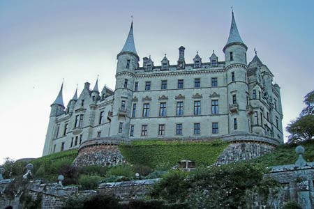
The primary objective of the walk is Ben Bhraggie. The statue just below the summit commemorates the life of the first Duke of Sutherland, which to this day is still highly controversial. Although well known for his achievements in road building and transport, he was heavily criticised for the large-scale eviction of thousands of people from their homes and Glens to achieve land improvements for farming communities. Whilst in the area, a must visit is Dunrobin Castle, approximately half a mile north of Golspie. This remarkable building was last rebuilt in 1845, and apart from being the largest, it is also the most northerly stately home on the British mainland.
The walk starts from the main car park behind the supermarket in the town centre of Golspie (grid ref. NC833001). From here, head north out of the town passing the fountain and continue through Rhives Farm taking the path to the left into the forest. Within minutes the path reaches a crossroad. Carry straight over until the next junction where you turn right to head north through the forest. Take time to find the huge variation of fungi on the forest floor, including the likes of Winter Fungus, Fly Agaric and Sickener.
Around 1km further on, the path reaches a T-junction. Turn left here on the wide path with the stone wall to your left. You are now on the recently built, EU funded, mountain bike track. Although this track is shared with bikers, it does not present too many problems as the path has adequate width to pass, although it pays to be alert at all times! Stay on this track as it leads you out of the forest and onto the northeast face of Ben Bhraggie.
After half an hour of climbing the path turns back on itself to reach the summit with the huge statue coming into view. At 100 foot tall this can be seen for miles down the coast. To the south, you can take in views right across Dornoch Firth towards Inverness 58 miles away and northwards the high peaks on the coast can just be seen if you know where to look. To return to Golspie, leave the statue by the steep track heading southeast towards the town below. Cross the mountain bike track back down into the forest and past the farm. Continue on the outward route back into town where a great morning on one of Sutherland's greatest coastal mountains is complete.
Other walks nearby
| Walk 1791 | Tarbat Ness from Porthmahomack | moderate | 9.0 miles |
| Walk 2504 | Struie circular | easy/mod | 4.5 miles |
| Walk 3287 | Morven, Smean & Maiden Pap | hard | 10.2 miles |
| Walk 1773 | Ben Wyvis (western approach) | mod/hard | 8.0 miles |
| Walk 1530 | Little Wyvis ascent from near Garve | moderate | 6.4 miles |
| Walk 1319 | The Bone Caves of Inchnadamph | easy | 3.0 miles |
| Walk 3272 | Conival & Ben More Assynt from Inchnadamph | hard | 11.0 miles |
| Walk 2274 | Cul Mor from Knockan Crag | mod/hard | 8.5 miles |
| Walk 1117 | Glas Bheinn & Eas a' Chual Aluinn (waterfall) | mod/hard | 8.5 miles |
| Walk 1317 | Sail Gharbh (Quinag) | moderate | 5.4 miles |
Recommended Books & eBooks
Skye's Cuillin Ridge Traverse
 This 2-volume set provides all the information required to complete the main ridge traverse on Skye's Black Cuillin. Strategy, gear, training, navigation and logistics are covered, and 10 classic scrambles are described. A lightweight second guidebook gives the scrambler detailed maps, topos and route description for the ridge traverse itself.
More information
Walking in Torridon
 This guidebook contains 52 day walks in Torridon, a remote and much-loved area of the Scottish Highlands. Based around Shieldaig and Slioch, the routes are split into 3 sections: easy walks, long and high level walks and mountain ascents over 2000ft including 9 Munros, and 5 outline suggestions for major ridge walks.
More information
Messaging & Social Media
Message Walking Britain and follow the latest news.

Mountain Weather
Stay safe on the mountains with detailed weather forecasts - for iOS devices or for Android devices.