The Newlands Horseshoe - Catbells, Dale Head & Hindscarth
Lake District Walk
Nat Park - Lake District - Lake District North Western Fells
Wainwrights - Catbells, Dale Head, High Spy, Hindscarth, Maiden Moor
County/Area - Cumbria
Author - Lou Johnson
Length - 12.0 miles / 19.5 km Ascent - 3420 feet / 1036 metres
Time - 9 hours 30 minutes Grade - mod/hard
Maps 

| Ordnance Survey Explorer OL4 | Sheet Map | 1:25k | BUY |
| Anquet OS Explorer OL4 | Digital Map | 1:25k | BUY |
| Ordnance Survey Landranger 90 | Sheet Map | 1:50k | BUY |
| Anquet OS Landranger 90 | Digital Map | 1:50k | BUY |
Walk Route Description
Click image to see photo description.
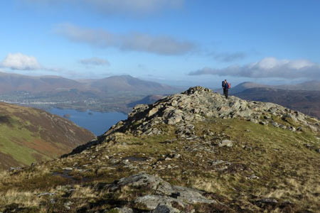
This is one of the great walks of the Lake District National Park and will keep you entertained for the best part of day, A day with good visibility is a must as the views throughout are engaging and you will see many of the Lakeland peaks during the circuit. Navigation is generally easy as you are following well trodden paths but do remember to save some energy for the steep 900 foot ascent from Dalehead tarn to the summit of Dale Head.
The start for this Lake District walk is the car park at the northern foot of Catbells at Gutherscale (grid ref. NY246211). On fine days this can be very busy and parking can be at a premium so an early start is recommended. After parking start the climb onto Catbells. There are two paths initially and these soon merge to form a clear path to the summit. The reward for this initial ascent of 1200 feet is the fine views across Derwentwater and the many surrounding fells.
Many of your fellow walkers will have fallen by the wayside as you continue on an ascending path roughly south to the summit of Maiden Moor. In my mind this is the most tedious section although the views remain as you head towards the cairn on the top of Blea Crag (630 metres). This is worth a short diversion as there is a fine view along the length of Derwentwater. After enjoying the view return to the main path and continue the gentle ascent to the summit cairn on High Spy.
You have a short section of respite as you descend to Dalehead tarn at the southern end of the Newlands Valley. From here it's a matter of gritting your teeth and steadily plodding uphill until you reach the summit cairn from where the view down Newlands and across to Eel Crags makes the effort worthwhile. You now head westwards along Hindscarth Edge with a different set of fells now included in the panorama to your left. It is important that you don't get too carried away with the views and miss the turn north towards the summit of Hindscarth with its well built cairn.
The hard work is now complete and you can enjoy a mainly downhill walk back to the start. The route from Hindscarth heads almost due north and descends to High Crags and then along the pleasant ridge to Scope End. From here the path descends more steeply down the eastern flank of the ridge to reach Low Snab. Here head north on the track towards the road at Chapel Bridge. Turn right along the road passing through the collection of dwellings at Little Town. Just after the last cottage take the path signed to Skelgill and follow this through pastures to reach the road at Skelgill. Bear right along the road and you are soon back at the start.
Other walks nearby
| Walk 1155 | Causey Pike | moderate | 6.3 miles |
| Walk 1187 | Robinson & Hindscarth | mod/hard | 6.5 miles |
| Walk 1356 | Walla Crag from Great Wood | easy/mod | 4.5 miles |
| Walk 3029 | Derwentwater & Walla Crag | easy/mod | 6.5 miles |
| Walk 3037 | High Seat & Bleaberry Fell from Keswick | moderate | 9.0 miles |
| Walk 2321 | Shores of Derwentwater from Keswick | easy | 3.5 miles |
| Walk 1108 | Ashness Bridge & Grange Fell | moderate | 9.0 miles |
| Walk 1120 | Grisedale Pike & Crag Hill fro Braithwaite | mod/hard | 8.5 miles |
| Walk 2038 | Tower Ridge on Eel Crag returning via Sail & Barrow | hard | 6.3 miles |
| Walk 1268 | Cat Bells & High Spy | moderate | 8.0 miles |
Recommended Books & eBooks
Hadrian's Wall Path
 Hadrians Wall Path guidebook to walk the 84 mile National Trail. Described in both directions, the main description is west to east between Bowness-on-Solway and Wallsend, Newcastle, with extensions to Maryport and South Shields. With extensive historical information related to this World Heritage site and separate 1:25,000 OS map booklet included.
More information
Outdoor Adventures with Children - Lake District
 Guidebook to 40 outdoor adventures in the Lake District with children under 12, including walking, cycling, orienteering, paddling, boating, hostelling and more. Graded activities for varying age ranges or for families with children of different ages.
More information
Messaging & Social Media
Message Walking Britain and follow the latest news.

Mountain Weather
Stay safe on the mountains with detailed weather forecasts - for iOS devices or for Android devices.