Walk 3136 - printer friendly version
Shining Tor & Goyt's Clough Walk
Author - Lou Johnson
Length - 5.1 miles / 8.3 km
Ascent - 900 feet / 273 metres
Grade - easy/mod
Start - OS grid reference SK018715
Lat 53.2405240 + Long -1.9744876
Postcode SK17 6TT (approx. location only)
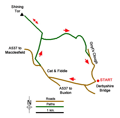
This Peak District walk visits Shining Tor, the highest point in Cheshire, before crossing heather moorland for a descent into Goyt's Clough and Derbyshire Bridge. The paths are easy to follow and the views excellent including Shutlingsloe (The Cheshire Matterhorn), Cat's Tor and Errwood Reservoir. There is a section of rough walking although this in descent and short. After heavy rain some sections of path may also be wet underfoot.
The start is the Derbyshire Bridge car park (grid ref. SK018715) where there are usually spaces even in fine weather. There are also public toilets. To reach the car park turn down from the A537 Buxton to Macclesfield Road near Tinker's Pit on Axe Edge Moor. Note that the lane running through Goyt's Clough north from the car park is one-way southbound.
After parking, exit the car park and follow the road uphill to reach the A537 at the Cat & Fiddle. This pub was closed in September 2017 and refreshments were available from a van parked in the lay-by opposite. Continue along the A537 towards Macclesfield using the wide verge. Where the A537 bends left, continue ahead onto a rough track (grid ref. SK000721). Follow this rising track taking the right fork after 250 metres. Continue the gentle ascent passing Stake Farm below on your left to reach a junction of paths and a gate (grid ref. SK000729). Take note of the footpath on the right as this will be sued later in the walk. Continue ahead through the gate and take the paved path on the left to reach the summit of Shining Tor (559 metres).
Allow time to enjoy the expansive view over Cheshire including the Cheshire Matterhorn (Shutlingsloe) and Lamaload Reservoir. To the north a long ridge extends to Cat's Tor and the Pym Chair. To the east views across the Goyt valley are excellent. To continue the walk, retrace your steps from the summit to reach the footpath junction at grid ref. SK000729). Turn left over either of the two stiles notes earlier and follow a clear path descending across the moorland. It is rough in places but not for long. The path soon reaches Stake Clough. After a brief ascent the path then briefly follows the edge of the plantation before passing through the trees.
Reaching a narrow wooden footbridge in Deep Clough (grid ref. SK011729) continue along the path through the trees. Ignore the path on the left descending to Goytsclough Quarry. The path soon leaves the plantation (grid ref. SK015727). The OS map shows a right of way contouring across the side of Goyt's Clough which meets the lane further up the valley. However, this can be very wet underfoot and a better option is to take the narrow path heading half left down to the road. All that remains is a steady uphill walk through Goyt's Clough over the Derbyshire Bridge and back to the start.
Messaging & Social Media
Message Walking Britain and follow the latest news.

Mountain Weather
Stay safe on the mountains with detailed weather forecasts - for iOS devices or for Android devices.