Walk 3208 - printer friendly version
Stoke & Hartland Quay Walk
Author - Lou Johnson
Length - 6.4 miles / 10.4 km
Ascent - 1200 feet / 364 metres
Grade - moderate
Start - OS grid reference SS231217
Lat 50.967486 + Long -4.5207414
Postcode EX39 6ES (approx. location only)
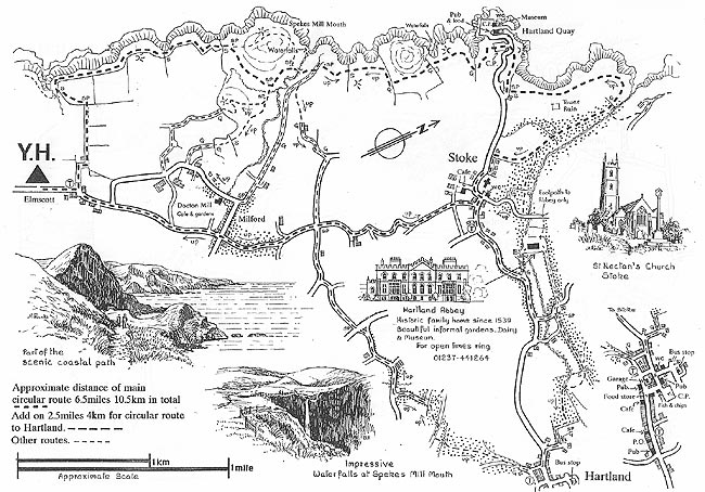
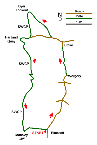
This Devon walk was originally conceived for walkers staying at the Elmscott Youth Hostel. The route starts from Elmscott (grid ref. SS231217) and continues north using country lanes and tracks to reach the village of Stoke where a diversion can be made to Hartland Abbey. The walk continues to the coast and then heads south following the South West Coast Path past Hartland Quay to return to the start. The coastal section of the walk offers views along an amazing section of cliffs and rugged coastline. An alternative place to start is the car park at Hartland Quay (grid ref. SS226247).
From the start at the Elmscott Youth Hostel turn left up the lane (north) and keeping straight ahead at all road junctions for 1.2 kilometres to descend into a steep sided valley at Lymebridge. It is worth noting that for a walk of this length there are many ups and downs along the way with the first ascent immediately after Lymebridge. Stay on the lane for a further 650 metres to reach a crossroads (grid ref. SS2362333) at Kernstone Cross.
Go straight across and continue along the lane until just before Wragery Farm where you bear left onto a track just before the farmyard gate. Stay on this track for a kilometre including a descent and renascent at a valley en-route. The track then becomes a narrow tarmac lane which is followed to the centre of Stoke Village (grid ref. SS235246).
Turn left along the road, passing public toilets and the parish church on the right. Enter the churchyard through the gate and continue with the church on your right to pass through the churchyard to a road (grid ref. SS234247). Continue west along the road. Pass a terrace of houses, signs showing the end of the speed limit and a white bungalow on the right. Just after take the signed footpath on the right with a view to the sea.
Follow the path downhill into Abbey Valley. Bear left at the first footpath junction and continue to the coast ignoring the footbridge on the right. The route now follows the South West Coast Path south (with the sea on your right). You are immediately faced with a steady climb onto the Warren before reaching a road and car park near Hartland Quay (grid ref. SS226247). This car park is the alternative starting point.
The South West Coast Path is well signed and takes you past the hotel, down into a valley and then a steady climb up to St Catherine's Tor. A steep descent into another valley where a footbridge takes you over a stream (grid ref. SS226234) before an undulating section generally gaining height to reach Milford Common which lies about one kilometre from the footbridge. Still climbing the South West Coast Path climbs steadily to a footpath junction (grid ref. SS223218) just before reaching Mansley Cliff. Turn left here and go half left across the first field to reach a track which continues across three fields (with the field boundary to your right) to become an enclosed track. This track leads to the road. Turn right and the Youth Hostel is a short way along on the right.
Editor's Note - parking in Elmscott is very limited. An overnight stay at the Youth Hostel would solve this problem.
This walk is one of many routes prepared by Martyn Hanks for Youth Hostellers. The routes were drawn in a 'Wainwright' style and provided annotated maps offering additional information for walkers. Prepared before the days of GPS they were an invaluable resource and Walking Britain is happy to ensure that these walks remain in the public domain.
Messaging & Social Media
Message Walking Britain and follow the latest news.

Mountain Weather
Stay safe on the mountains with detailed weather forecasts - for iOS devices or for Android devices.