Walk 3242 - printer friendly version
Holy Island - Lindisfarne Castle & Emmanuel Head Walk
Author - Lou Johnson
Length - 4.4 miles / 7.2 km
Ascent - 150 feet / 45 metres
Grade - easy
Start - OS grid reference NU125423
Lat 55.6740400 + Long -1.8028151
Postcode TD15 2SX (approx. location only)
Holy Island, or Lindisfarne, lies off the Northumberland coast. The island has many historic and religious connections with many tourists in season. In addition, Holy Island sees many species of birds throughout the year attracting many ornithologists. Despite the number of visitors to the island, it is possible to enjoy some solitude and this walk does just that visiting the east coast and the dunes in the north.
Careful planning is required before making a visit. Holy Island is cut off from the mainland at high tide so ideally you should arrive just as the road becomes passable on a falling tide. This walk, allowing for some leisurely exploration of the village, takes about three hours. If in doubt do not start the walk as the alternative is being stranded on the island!
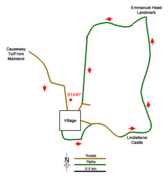
After crossing the causeway, you reach a large pay and display car-park on the left (grid ref. NU125423). This is as convenient as the other car park in the village. After parking follow the road into the village and continue to the parish church. The church is adjacent to the ruined Priory for which admission charges apply. Visiting the church and churchyard is free. Continue through the churchyard and exit via the gate to the west of the church. Turn left and follow the path which soon crosses a small rocky outcrop offering a good view south to Bamburgh Castle.
Descend to follow a track between upturned hulls now used for storage. Bear right onto the tarmac access drive to Lindisfarne Castle. Just prior to the castle the lane forks. Keep left here and continue along the northern flank of the castle. The tarmac ends and becomes a clear track which is followed to reach the eastern shore of the island. Turn left along the coast following the path nearest the sea. Ahead you will see the white triangular landmark at Emmanuel Head which is the next objective. The landmark has the benefit of some wooden benches you wish to linger and enjoy the views and solitude.
To continue, walk east following paths on the dunes. There are many possible routes but I found the best option was stay as high as possible keeping to a sandy 'ridge' for just over 600 metres. With the benefit of height, you can see the sign at the end of the enclosed lane at grid ref. NU129432. Using one of the many paths through the sandy landscape this was soon reached. Once at the end of the lane, walk south back into the village passing St Combs farm on the left. To reach the large car park, take the next right passing the coach park (on your right). Reaching the main road into the village, turn right again and the car park is a short up this road on the right.
Messaging & Social Media
Message Walking Britain and follow the latest news.

Mountain Weather
Stay safe on the mountains with detailed weather forecasts - for iOS devices or for Android devices.