Stowe Park from Chackmore
Buckinghamshire Walk
County/Area - Buckinghamshire - North Buckinghamshire
Author - Lou Johnson
Length - 4.3 miles / 7 km Ascent - 250 feet / 76 metres
Time - 2 hours 20 minutes Grade - easy
Maps 

| Ordnance Survey Explorer 192 | Sheet Map | 1:25k | BUY |
| Anquet OS Explorer 192 | Digital Map | 1:25k | BUY |
Walk Route Description
Click image to see photo description.
This Buckinghamshire walk follows the boundary of majestic Stowe Park where Capability Brown was first employed as head gardener. The paths used for this walk do not enter Stowe Park which is a National Trust property. However, you may wish to pay the admission to see the grounds close at hand. The start is the small free car park at the western end of Chackmore village (grid ref. SP683357) close to Stowe Avenue.
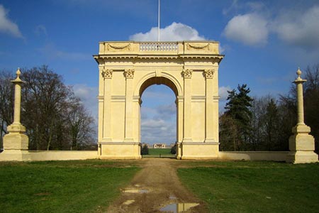
After parking, turn right along Stowe Avenue and continue to the Corinthian Arch. Just before the arch you reach a junction. Turn left and follow the Ouse Valley Way soon passing through a gate adjacent to a cattle grid. Stay on the clear track passing between two lakes. Four hundred metres past the lakes you reach a road junction flanked by two pavilions (grid ref. SP669369).
Bear half right and follow the straight road through an avenue of mature trees (initially still on the Ouse Valley Way). On your right is the rear of Stowe House which is now an independent school. Continue past the National Trust Visitor Reception and car park on your right. Ahead you can see Wolfe's Obelisk on the left. Continue along the road following it round to the right and ignoring the track going straight ahead. Walk to the small gate with waymarks ahead.
Go through the gate into a field. At the end of the field, cross the stile and continue along the edge of the next field to a gate by a cottage on your right. Go through the gate into a field and follow the bridleway which initially heads southeast. Cross the small stream (grid ref. SP683373). Continue along the track in a southerly direction to reach a track on the right that leads to the New Inn Visitor Centre (grid ref. SP684387). From this track follow the bridleway south across fields to reach a road just west of Chackmore village (grid ref. SP687360). Turn left along this road back to the start.
Other walks nearby
| Walk 2396 | Finmere & Westbury | easy/mod | 6.1 miles |
| Walk 2755 | Great Horwood & Adstock circular | easy | 5.5 miles |
| Walk 2968 | Hillesden from Steeple Claydon | easy | 4.5 miles |
| Walk 2628 | Charndon & Edgcott | easy | 6.0 miles |
| Walk 2490 | Quainton & North Marston Circular | easy/mod | 6.8 miles |
| Walk 3611 | Ashby Gorse from Moreton Pinkney | easy | 5.7 miles |
| Walk 2549 | Roade to Weston Underwood | easy/mod | 10.5 miles |
| Walk 2449 | Canons Ashby Circular | easy | 5.0 miles |
| Walk 3042 | Thenford Hill & Upper Wardington from Middleton Cheney | easy/mod | 7.5 miles |
| Walk 1794 | Litchborough & Farthingstone Circular | easy/mod | 6.0 miles |
Recommended Books & eBooks
No suggestions for this area.Messaging & Social Media
Message Walking Britain and follow the latest news.

Mountain Weather
Stay safe on the mountains with detailed weather forecasts - for iOS devices or for Android devices.