Walk 3264 - printer friendly version
Port Quin & Port Isaac Circular Walk
Author - Lou Johnson
Length - 5.7 miles / 9.3 km
Ascent - 900 feet / 273 metres
Grade - easy/mod
Start - OS grid reference SW972805
Lat 50.5889210 + Long -4.8664070
Postcode PL29 3SU (approx. location only)
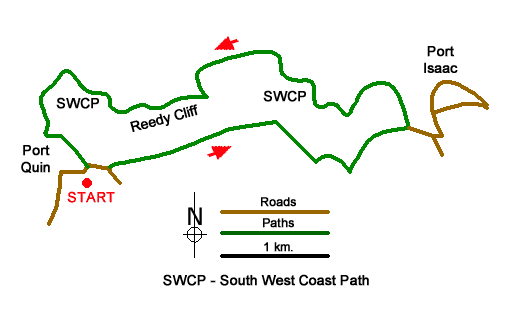
This circular walk from Port Quin to Port Isaac offers a taste of the north Cornwall coast and countryside. The outward route follows an inland path. After exploring Port Isaac with its wide range of amenities, the return route follows the South West Coast Path along a lovely section of coast back to the start.
The start is the small National Trust car park at Port Quin (grid ref. SW972805). After parking exit the car park and turn right up the lane and continue to the first footpath sign on the left (Port Isaac - inland route). Continue in front of cottage and keep straight ahead to follow a well-trodden path with hedge on your right. Reaching the second field keep ahead on the path to join a clear track. Follow this track for about a kilometre to where the track turns sharp right towards Roscarrock Farm (grid ref. SW988805). At this point turn left (hedge on left) and follow the path which soon descends to a footbridge in a valley.
Cross the footbridge and turn left. Immediately bear half right up the hillside. Continue to a stile in the hedge (grid ref. SW992807). Continue along the left side of the field along a clear path. The path soon leads you through a gate to join a road (Roscarrock Hill). Descend the lane into the centre of Port Isaac (grid ref. SW 996807).
To explore Port Isaac, continue ahead past the Lifeboat Station on your right. Continue up narrow Fore Street to turn right into Back Hill (opposite the Old School). A steady climb up Back Hill leads you into to New Road. Descend to the sea front. Turn left into New Road long-stay car park and pick up the path along the cliff tops (grid ref. SX00810). You are now on the South West Coast Path.
Follow the SWCP around the headland (sea on your right). The path will lead you back into Fore Street. Continue down to pass the Lifeboat Station (now on your left) and bear right up Roscarrock Hill. At the end of this road Turn right to join the SWCP, which is followed back to Port Quin. It is a lovely section of coast. The first objection is Lobber Point after which you descend to a footbridge at Pine Haven. An ascent to Varley Head is soon followed by a view along Reedy Cliff to Kellan Head. After Kellan Head the path turns south and returns to Port Quin. It is worth noting that the path is easy to follow although there are some sections of steps.
Messaging & Social Media
Message Walking Britain and follow the latest news.

Mountain Weather
Stay safe on the mountains with detailed weather forecasts - for iOS devices or for Android devices.