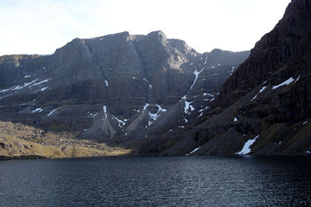
Loch Coire Mhic Fhearchair (Beinn Eighe)
Highland Walk
County/Area - Highland - Central Highland
Author - Lou Johnson
Length - 8.3 miles / 13.5 km Ascent - 1750 feet / 530 metres
Time - 5 hours 50 minutes Grade - moderate
Maps 

| Ordnance Survey Explorer 433 | Sheet Map | 1:25k | BUY |
| Anquet OS Explorer 433 | Digital Map | 1:25k | BUY |
Walk Route Description
Click image to see photo description.
This Torridon walk ignores the high peaks and follows an excellent path between the towering crags of Liathach and Beinn Eighe to reach Loch Coire Mhir Fhearchair which nestles below the spectacular triple buttress of Coinneach Mhor, Sail Mhor and Ruadh stac-Mhor. The route climbs steadily into the mountains providing a relaxing approach from which to enjoy the rocky mountain landscape.
The start is the Beinn Eighe car park (grid ref. NG958568) which lies on the north side of A896 about six miles south-west of Kinlochewe. From the approach road you already have some idea of the landscape to be explored with Liathach and Beinn Eighe both clearly in view.
After parking take the path signed to Coire Mhic Nobail. The excellent path initially climbs quite steeply across the eastern flank of Liathach. After three kilometres you reach stepping-stones across the main valley stream (grid ref. NG947589). Continue up the clear path for just over another kilometre. After passing a small lochan on your right you reach a cairn (grid ref. NG935594).
Fork right here and continue as the path crosses the lower slopes of Sail Mhor on your right. The path the sweeps right before making a steeper approach the shores of Loch Coire Mhic Fhearchair. The shores of the loch are a perfect place for a rest allowing you to take in the details of this rocky amphitheatre. All that remains is to retrace your steps down the path back to the start.
Other walks nearby
| Walk 2593 | Liathach, Glen Torridon | very hard | 8.5 miles |
| Walk 1305 | Sgurr nan Fhir Duibhe from Kinlochewe | hard | 7.5 miles |
| Walk 1347 | Meall a' Ghiubhais from Kinlochewe | moderate | 8.0 miles |
| Walk 1344 | Beinn Alligin & Sgurr Mor | mod/hard | 6.0 miles |
| Walk 2468 | The Falls of Glomach from Morvich | moderate | 7.5 miles |
| Walk 2106 | Ullapool - a Munro Quartet including Beinn Dearg | very hard | 16.0 miles |
| Walk 1018 | Beinn Ghobhlach | moderate | 6.0 miles |
| Walk 1886 | Carn a' Bhealaich Mhoir | easy/mod | 8.0 miles |
| Walk 1781 | Loch Affric Circular | moderate | 11.0 miles |
| Walk 1789 | Mam Sodhail & Carn Eighe | hard | 14.4 miles |
Recommended Books & eBooks
Walking in Torridon
 This guidebook contains 52 day walks in Torridon, a remote and much-loved area of the Scottish Highlands. Based around Shieldaig and Slioch, the routes are split into 3 sections: easy walks, long and high level walks and mountain ascents over 2000ft including 9 Munros, and 5 outline suggestions for major ridge walks.
More information
Walking the Munros Vol 2 - Northern Highlands and the Cairngorms
 Guidebook to walking the northern Munros, covering the northern Highlands, the Cairngorms and the Isle of Skye. 70 routes are described, including those up Ben Macdui, Braeriach and Cairn Gorm. Routes range from 7 to 46km, requiring a fair level of fitness. The second of two guidebooks to walking Scotland's Munros: peaks higher than 3000ft.
More information
Messaging & Social Media
Message Walking Britain and follow the latest news.

Mountain Weather
Stay safe on the mountains with detailed weather forecasts - for iOS devices or for Android devices.