West Lomond from near Gateside Walk
Walk 3280 - Route Maps & Profile
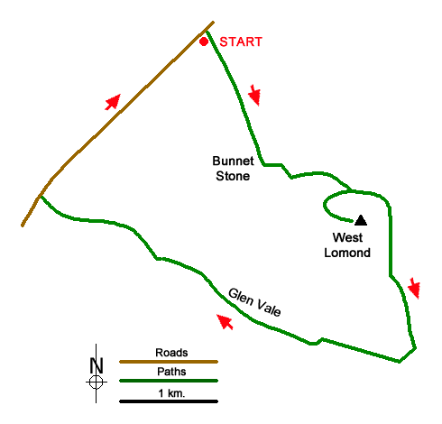
Route Map
Digital Maps - Copyright © 2011-2024. All rights reserved.
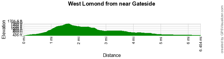
Route Profile
Sketch Map
Suggested Maps 

| Ordnance Survey Explorer 370 | Sheet Map | 1:25k | BUY |
| Anquet OS Explorer 370 | Digital Map | 1:25k | BUY |
It is recommended you take a map. The preferred scale is 1:25k.
Start Point Details
Ordnance Survey Grid Ref NO185082
Latitude 56.25928 Longitude -3.317182
Postcode KY14 7RR
what3words start earth.presenter.noses
Walk description may contain detailed information on the start point for this walk.
Further Information
Fife
The peninsula of Fife lies between the Firth of Tay and Firth of Forth. The east coast faces the North Sea. The best walking is along the coast and in the Lomond Hills. These hills are extinct volcanoes with West Lomond the highest summit (522 metres, 1,713 ft). The coast has several small harbours which can be linked by the coast path which include Anstruther, Pittenweem and the university town of St. Andrews.
Walk grading - Learn how each walk is assessed and select a walk to suit your ability and experience by going to Walk Grading Details.
Messaging & Social Media
Message Walking Britain and follow the latest news.

Mountain Weather
Stay safe on the mountains with detailed weather forecasts - for iOS devices or for Android devices.