Walk 3285 - printer friendly version
The Hergest Ridge and Huntington from Kington Walk
Author - Peter Lane
Length - 12.0 miles / 19.5 km
Ascent - 1800 feet / 545 metres
Grade - moderate
Start - OS grid reference SO296565
Lat 52.202213 + Long -3.031533
Postcode HR5 3TA (approx. location only)
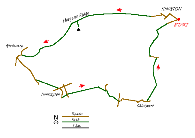
A ridge walk on one of the finest parts of the Offa's Dyke path followed by a rural odyssey through typical Herefordshire countryside with grand views back to the Hergest Ridge. Starting from the quaint market town of Kington near the Welsh border, this route has much to offer. In places the route can be very wet underfoot and overgrown. Long trousers are essential and gaiters recommended in wet conditions.
The start point for this walk is the pay and display car park opposite the museum in Crabtree Road off Mill Street West, grid reference SO296565. This is a convenient spot with facilities opposite and ready access to the town for browsing, eating, drinking or visiting the free museum. Impecunious ramblers can drive further up Mill Street and park on the road near the recreation ground for free.
Leave the car park and return towards the High Street, turning up the hill on Church Street to the Church of St. Mary the Virgin. Pass through the churchyard and then cross Montfort Road and head up Ridgebourne Road, signposted to Hergest Croft Gardens. This road becomes a track which is well signposted as the Offa's Dyke National Trail (acorn symbol). This route is straightforward over the entire ridge. Look out for the remains of the racecourse around the summit and, obviously, the spectacular views. Marilyn hill and trig point baggers will have to make a slight detour to the left to achieve the summit proper. This worthwhile, short diversion will afford some great views back to the Shropshire hills and forward to the Welsh hills.
Descend on the well marked path to a metalled road, turn right and enter Gladestry. Walk past the pub, continue up the road, turn left, cross the brook and left again still following the Offa's Dyke Path. Follow this for 800 metres to a bend in the road and then depart from the Offa's Dyke Path, continuing up the very steep hill for another 400 metres until a farm access appears on the left (Pen-twyn) and a bridlepath. Follow this enclosed bridlepath, frequently gated, all the way to Huntington village. On reaching a tarmac lane, turn right and emerge shortly at Huntington Village Hall.
On the left a steep and rough footpath leads directly up the steep bank of Huntington Castle earthwork should your curiosity take you there. Cross the road at the Village Hall, pass the caravan club site and follow the road around to a small green and an old fashioned red phone box. Follow the sign to Huntington Court and the Church. Upon reaching the Church of St. Thomas ŕ Becket, enter the churchyard through the kissing gate and immediately leave it through another, following the footpath around to the left of the churchyard. At a stile, pick up the driveway and cross a country lane. The path continues through fields, following the hedge-line on the left. When the hedge runs out, keep to the left of the small stream and the hedge will re-appear before the path enters Huntington Park, a small wood.
A few metres after entering the wood, a footpath is signed to the right. Take this and follow it to an open field. Pass through this field and cross the brook via a footbridge. Turn left after the bridge and emerge at a stile. Turn left from the stile and then right along a road marked "unsuitable for motor vehicles": good advice! Before this track reaches the ford on the River Arrow, look out for a stile on the left (easily missed) which will convey you safely over the river on a footbridge. At the end of this track, cross the road and follow the minor road opposite past Empton Farm to Chickward. Upon reaching the farm at Chickward, pass the farmyard entrance and 25 yards down the road on the left a stile is provided through the hedge where you will see the finger post for the footpath. Follow through to a field on the right and a footpath occasionally marked as the Herefordshire Trail (possibly now an obsolete designation).
The path follows the hedge-line to the right until a fork appears. Follow the waymark forking slightly left to a stile in the hedge opposite and continue on the same bearing until reaching a stile and a bewildering cross-roads of footpaths. Two fingerposts denote routes in no less than six directions! However, some are duplicates and there are actually only four paths. Quite simply, carry straight on up the hill, emerging onto a country lane. Turn left and drop down the steep hill where the footpath resumes near the bottom on the right where a fingerpost points the way up some steps climbing the steep bank.
Follow the path indicated by the left arrow (there is only one path on my Explorer Map!) and then continue on a strip of land sandwiched between woods to the left and right until a fingerpost on the left shows a path down to a footbridge crossing the River Arrow. Cross over, walk past a mill and then at the road, turn 90 degree right to continue along a footpath passing a pond and then reaching some playing fields and the Recreation Ground. This emerges onto Park Avenue and Mill Street, bringing you back directly to the car park. Take some time to explore the free museum and pleasant market town.
Messaging & Social Media
Message Walking Britain and follow the latest news.

Mountain Weather
Stay safe on the mountains with detailed weather forecasts - for iOS devices or for Android devices.