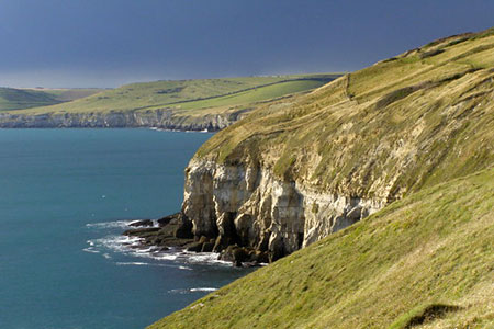
Dancing Ledge & Durlston Head from Langton Matravers
Jurassic Coast Walk
Region - Jurassic Coast
County/Area - Dorset
Author - Lou Johnson
Length - 7.0 miles / 11.4 km Ascent - 800 feet / 242 metres
Time - 4 hours 20 minutes Grade - easy/mod
Maps 

| Ordnance Survey Explorer OL15 | Sheet Map | 1:25k | BUY |
| Anquet OS Explorer OL15 | Digital Map | 1:25k | BUY |
Walk Route Description
Click image to see photo description.
This walk from Manton Matravers (Dorset) explores a beautiful stretch of the Jurassic Coast by following a section of the South West Coast Path. The route includes Dancing Ledge, Blackers Hole, Durlston Head and Castle. The Jurassic Coast is a World Heritage Site selected for its fossils, geology, and natural landforms.
The walk starts from the Spyway car park (grid ref. SY997783). The car park is signed from the High Street in Langton Matravers and is approached down a narrow lane (Durnford Drove). After parking, follow the clear track towards the sea. Continue ahead at the junction and follow the path past Spyway Barn. Continue to reach the coast and South West Coast Path at Dancing Ledge (grid ref. SY997770).
Turn left with sea to your right. You can make a short diversion to Dancing Ledge by crossing a stile. You now have four kilometres of wonderful walking along the coast to Durlston Head. Along the way you pass Anvil Point lighthouse and the Tilly Whim Caves. As you get close to Durlston Head you pass the limestone Globe and Durlston Castle before reaching the headland. Leave the South West Coast Path and continue along the path signed 'Woodland Wildlife' and turn left on a tarmac drive (grid ref. SZ033773).
Reaching a gate (grid ref. SZ031772) veer right off the tarmac drive to follow a grassy path. The path soon forks. Bear right and continue west to pass through a gate (grid ref. SZ027772). Keep ahead along a path which keeps to the high ground keeping the wall on your right. After a kilometre you reach a wall corner (grid ref. SZ018771). Continue along the path which runs parallel to a wall on your right. After 200 you reach the end of this wall. Turn right and follow the path inland with wall on your right.
The path soon joins a track from a stone quarry. Follow this track north for a kilometre to reach a cross track before Belle Vue Farm (grid ref. SZ015782). Turn left and continue for 600 metres. Continue past a barn on your right to a T-junction. Turn left and follow the track around a right-hand bend to pass more barns on your right. %00 metres beyond these barns the track forks. Bear right here and shortly after at the next junction, bear right again. Continue along this track back to the start.
Other walks nearby
| Walk 2925 | St Aldhelm's Head near Worth Matravers | easy | 4.1 miles |
| Walk 2579 | Purbeck Coast from Swanage | moderate | 10.0 miles |
| Walk 2145 | Houns-tout Cliff from Kingston | easy | 3.5 miles |
| Walk 1634 | Old Harry & Ballard Down from Studland | easy/mod | 5.3 miles |
| Walk 3396 | Agglestone & Old Harry Rocks | easy/mod | 6.4 miles |
| Walk 1331 | Kimmeridge & Tyneham | easy/mod | 6.8 miles |
| Walk 1534 | Swyre Head & Tyneham Cap from Kimmeridge | moderate | 11.8 miles |
| Walk 1995 | Houns-tout & Swyre Head from Kimmeridge | moderate | 8.7 miles |
| Walk 1613 | Studland & Old Harry Rocks | easy/mod | 8.5 miles |
| Walk 2568 | Egmont Point & Kimmeridge Bay from Tyneham | moderate | 14.0 miles |
Recommended Books & eBooks
The South West Coast Path
 Guidebook to walking the entire South West Coast Path National Trail. The route runs for 630 miles from Minehead to Poole along the north Devon, Cornish, south Devon and Dorset coastline. Divided into 45 stages, this long-distance coastal trek could be completed within 4 weeks, or walked in sections. Guide includes maps and essential information.
More information
South West Coast Path Map Booklet - Minehead to St Ives
 Map of the northern section of the 630 mile (1014km) South West Coast Path National Trail. Covers the trail from Minehead to St Ives along the north Devon and Cornish coastline. This convenient and compact booklet of Ordnance Survey 1:25,000 maps shows the route, providing all of the mapping you need to walk the trail in either direction.
More information
Messaging & Social Media
Message Walking Britain and follow the latest news.

Mountain Weather
Stay safe on the mountains with detailed weather forecasts - for iOS devices or for Android devices.