Walk 3316 - printer friendly version
Rockcliffe to Kippford Walk
Author - Mike Bexley
Length - 3.0 miles / 4.9 km
Ascent - 250 feet / 76 metres
Grade - easy
Start - OS grid reference NX847537
Lat 54.864749 + Long -3.7979841
Postcode DG5 4QQ (approx. location only)
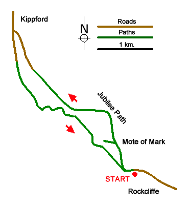
This short beautiful circular walk from Rockcliffe follows The Muckle Walk & Jubilee Path through old woods with the option of visiting the Mote of Mark. It then passes a collection of curios on the way back. Although I have quoted map grid references, a map is not required just follow this description. The advantage of starting from Rockcliffe as against Kippford is the ease of parking and the option of a refreshing drink and or meal mid-way.
The seaside village of Rockcliffe is situated off the main A710 Dumfries to Dalbeattie road. This walk starts from the large car park on the left just as you drop down to the village (Grid ref. NX847537). Exit the car park and take the narrow lane opposite with its views across the bay, continue straight along this lane to its end and into the woods. On the left is signed The Mote of Mark the site of a 6th century AD fort. It is a short steep climb to the top and the views are fantastic. Use the same path to descend the hill and rejoin the main path. This path, with it's many benches and seats, is very clear. Do not be tempted or confused by the many paths joining this path. Just keep straight ahead. You emerge from the woods onto a road leading down to the gift shop (Grid ref. NX837549) and the river front of Kippford. Turn right for the Anchor Inn.
To proceed with the walk, return to the gift shop and walk along the road with the river estuary on your right. It is along this road that you pass an interesting collection of objects, animals and people made out of stones and drift wood. Towards the end look out for a lane on your left, just after Elm Cottage. The path climbs steeply up into the woods. Again keep to the main path, with the estuary always on your right. The path joins a lane prior to a footbridge then its swing gates, cattle grids and green meadows leading to Rockcliffe (the toilet block in fact). Turn left then right along the front and up the hill passing the Tearooms to the car park.
Messaging & Social Media
Message Walking Britain and follow the latest news.

Mountain Weather
Stay safe on the mountains with detailed weather forecasts - for iOS devices or for Android devices.