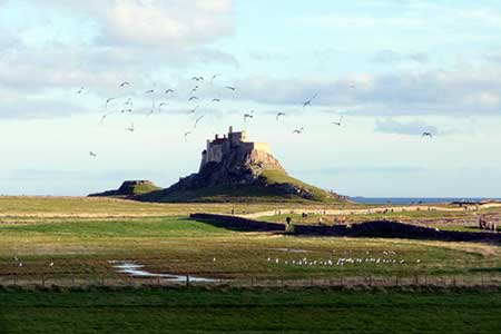
Holy Island & Lindisfarne Castle Circular
Northumberland County Walk
County/Area - Northumberland County
Author - Lou Johnson
Length - 4.3 miles / 7 km Ascent - 100 feet / 30 metres
Time - 2 hours 20 minutes Grade - easy
Maps 

| Ordnance Survey Explorer 340 | Sheet Map | 1:25k | BUY |
| Anquet OS Explorer 340 | Digital Map | 1:25k | BUY |
Walk Route Description
Click image to see photo description.
Holy Island, off the Northumberland coast, has many historic connections and sees many tourists. However once away from the village and Lindisfarne Castle you will enjoy some wild coastal scenery in relative solitude. Holy Island is cut off from the mainland at high tide so careful planning is required before starting this walk, which should take under three hours. Ideally you need to cross the causeway just as the road becomes passable on a falling tide. Safe crossing times are available from tourist information. Remember the road is closed for about seven hours between tides so do allow enough time to cross back to the mainland to avoid being stranded on the island.
The start is the car park on the north side of the village (grid ref. NU125423). After parking walk into the village and continue to the parish church, which is adjacent to the ruined Priory. If you wish to the visit the latter then admission charges apply. Continue through the churchyard and exit via the gate to the west of the church. Once through the gate, turn left and follow the path across a rocky outcrop and down through the boatyard. Continue along a clear track that leads you along the harbour to reach a tarmac road. Follow this tarmac road towards Lindisfarne Castle.
Just prior to the castle the lane forks. Keep to the left here and pass the northern side of the castle. The tarmac soon ends and you should continue on the track to reach the eastern coast of the island. Here, head north walking parallel with a wall on your left and the coast to your right. Continue for about a kilometre to pass The Lough on your left (grid ref. NU137429). Soon after the path turns left (grid ref. NU135432) at a field boundary. The clear path heads west with dunes to your right and continues to a junction with a track (grid ref. NU129432). Do not turn left down the track but continue ahead on the path. Which soon loops left and takes you to the causeway road (grid ref. NU124425). Turn right along the road and take the first path on your left. This path follows the shoreline back to the centre of the village.
Other walks nearby
| Walk 2738 | Budle Bay from Bamburgh | easy | 4.0 miles |
| Walk 3522 | Bamburgh Castle circular | easy/mod | 7.5 miles |
| Walk 2677 | Circuit of Doddington Moor | easy | 3.8 miles |
| Walk 2282 | Bewick Moor | moderate | 9.1 miles |
| Walk 1199 | Dunstanburgh Castle | easy | 4.5 miles |
| Walk 3335 | Howick & Cullernose Point | easy | 4.5 miles |
| Walk 2397 | Beadnell to Craster | easy/mod | 7.9 miles |
| Walk 1764 | The Cheviot from Langleeford | mod/hard | 8.2 miles |
| Walk 1765 | Comb Fell & Hedgehope Hill from Langleeford | mod/hard | 8.9 miles |
| Walk 1776 | The Cheviot & Auchope Cairn from Langleeford | mod/hard | 10.0 miles |
Recommended Books & eBooks
Hadrian's Wall Path
 Hadrians Wall Path guidebook to walk the 84 mile National Trail. Described in both directions, the main description is west to east between Bowness-on-Solway and Wallsend, Newcastle, with extensions to Maryport and South Shields. With extensive historical information related to this World Heritage site and separate 1:25,000 OS map booklet included.
More information
Walking in Northumberland
 This guidebook contains detailed route descriptions for 36 day walks in Northumberland including the Cheviot Hills. The terrain varies from wild walks and craggy ascents to gentle riverside strolls. Each route ranges from 4 to 16 miles in length and there is the opportunity to link several walks together to create longer treks.
More information
Messaging & Social Media
Message Walking Britain and follow the latest news.

Mountain Weather
Stay safe on the mountains with detailed weather forecasts - for iOS devices or for Android devices.